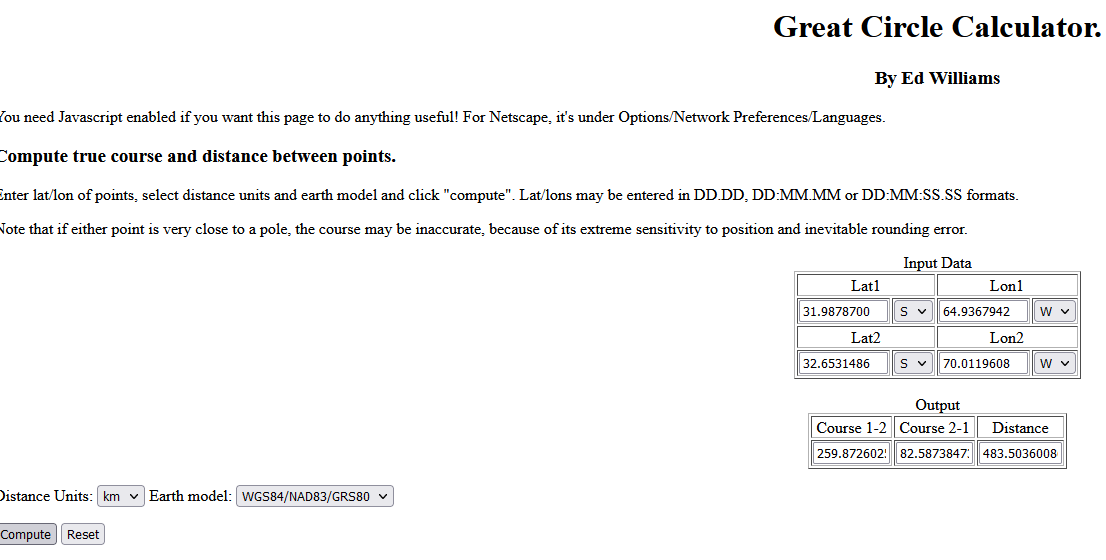
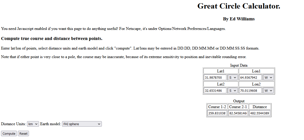
484,5 km – Andes from the Cordoba area. World record! / Andy z okolic Cordoby. Rekord świata !
💡 Ważna aktualizacja – Important update
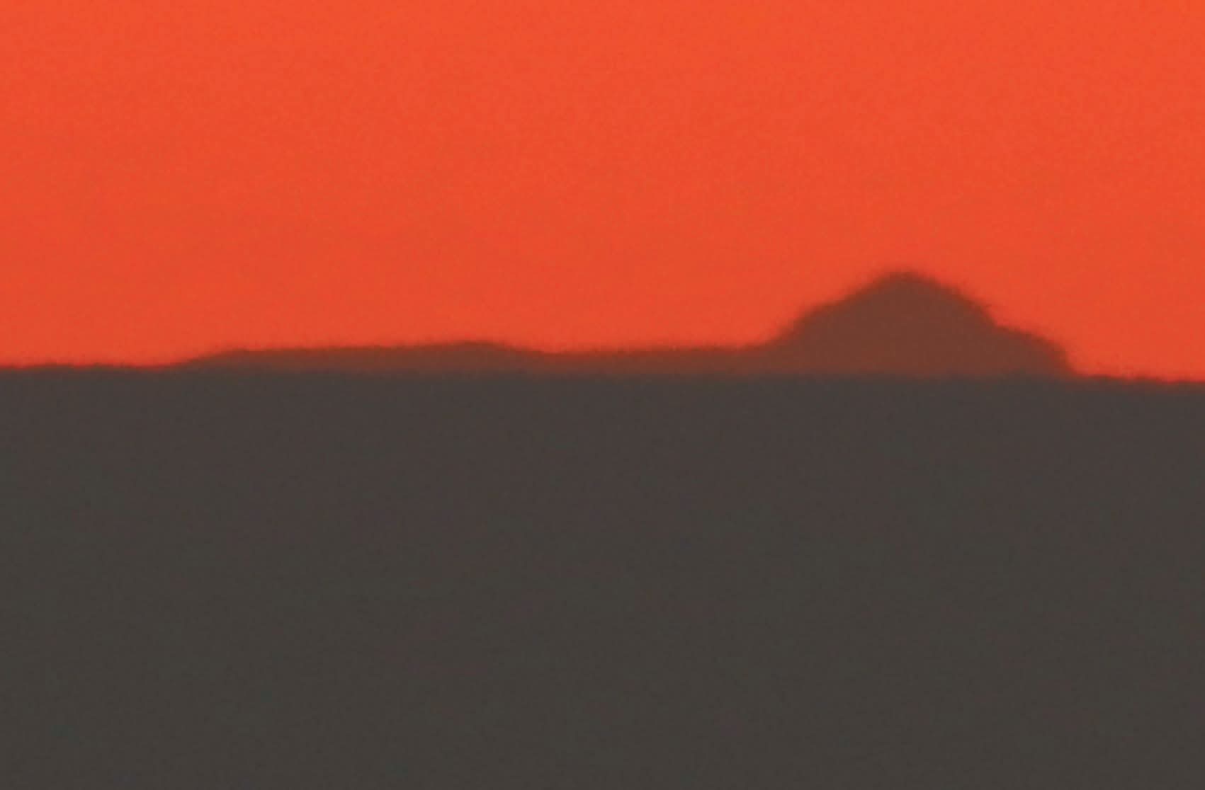
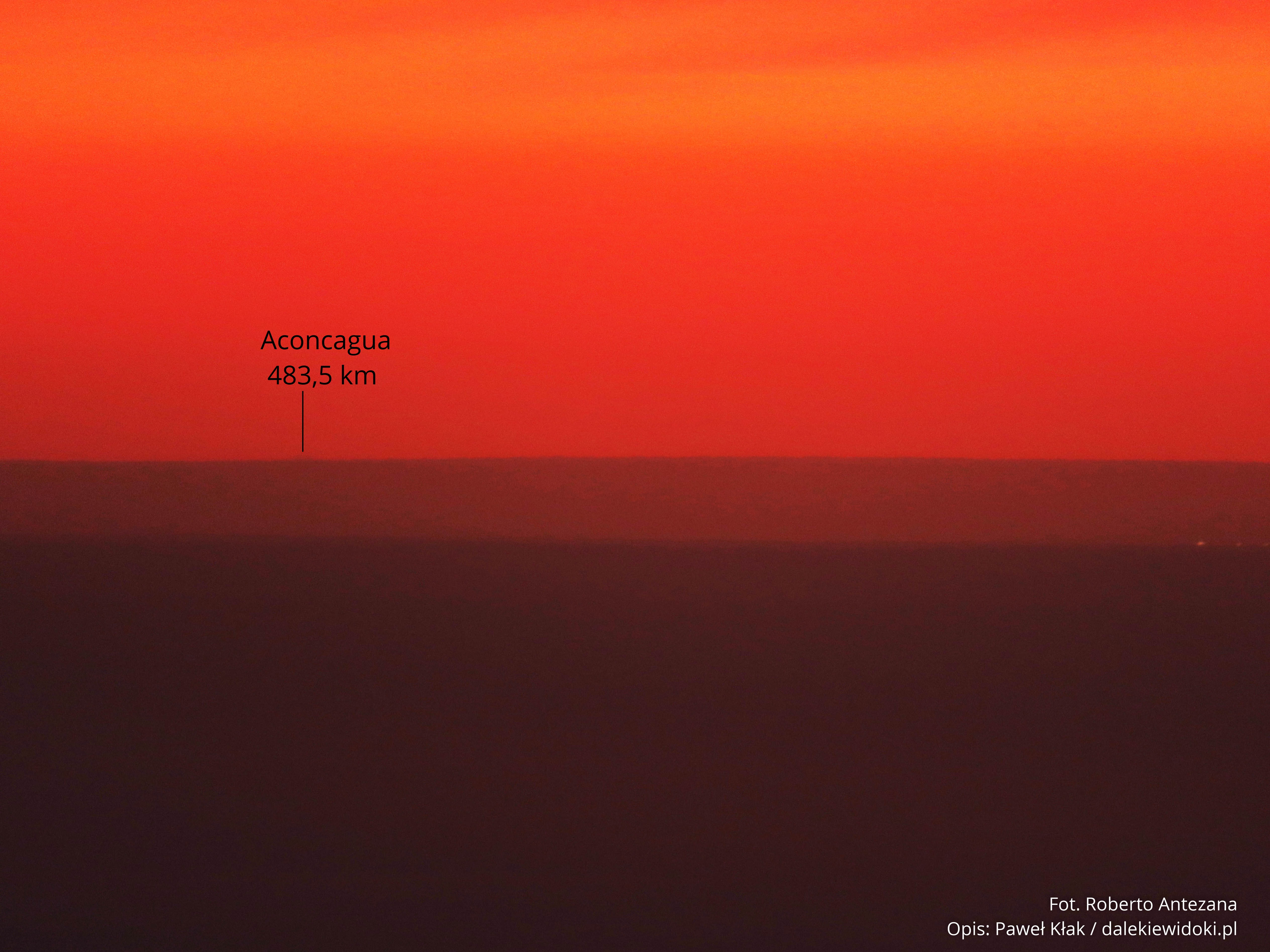
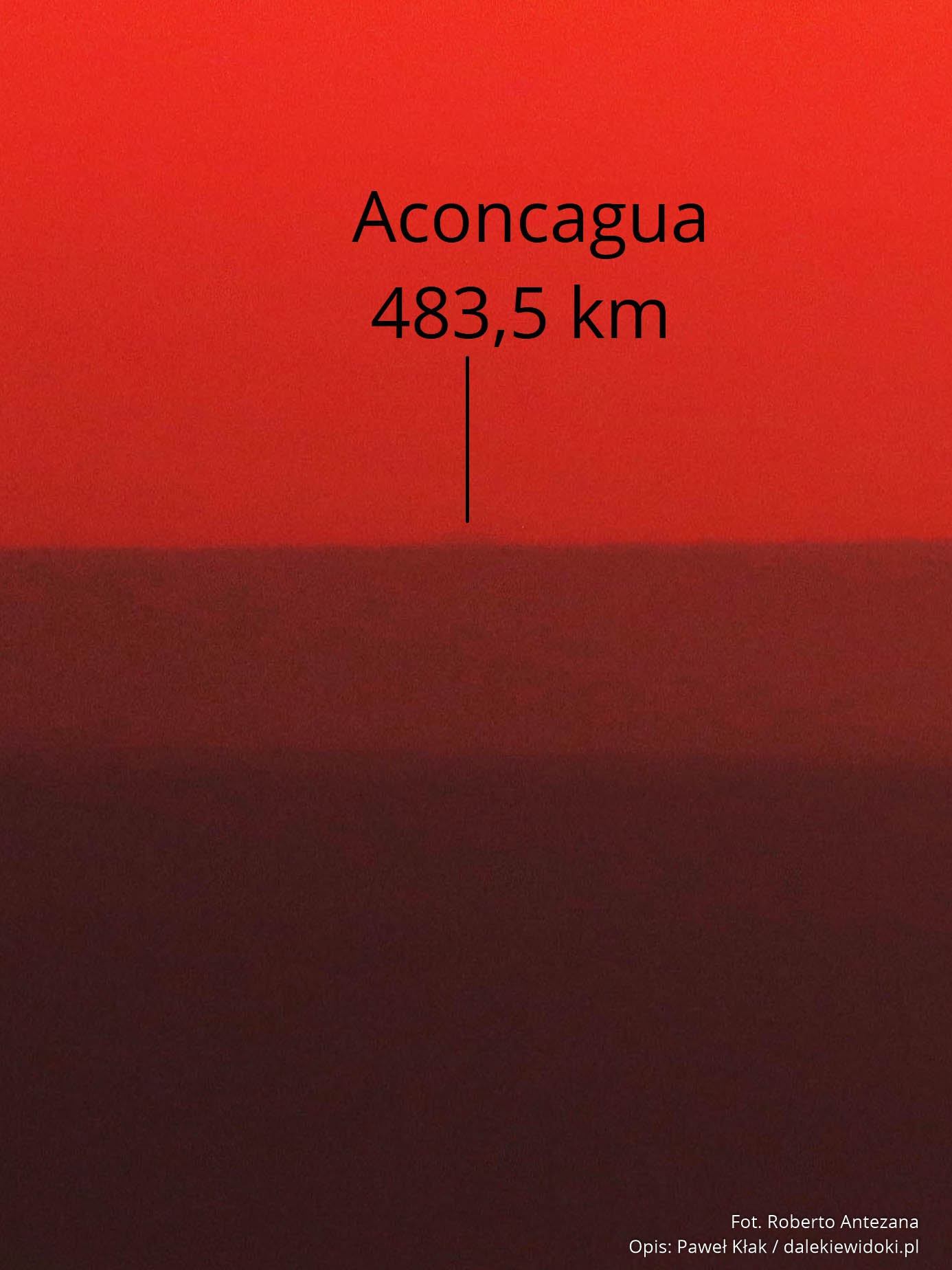
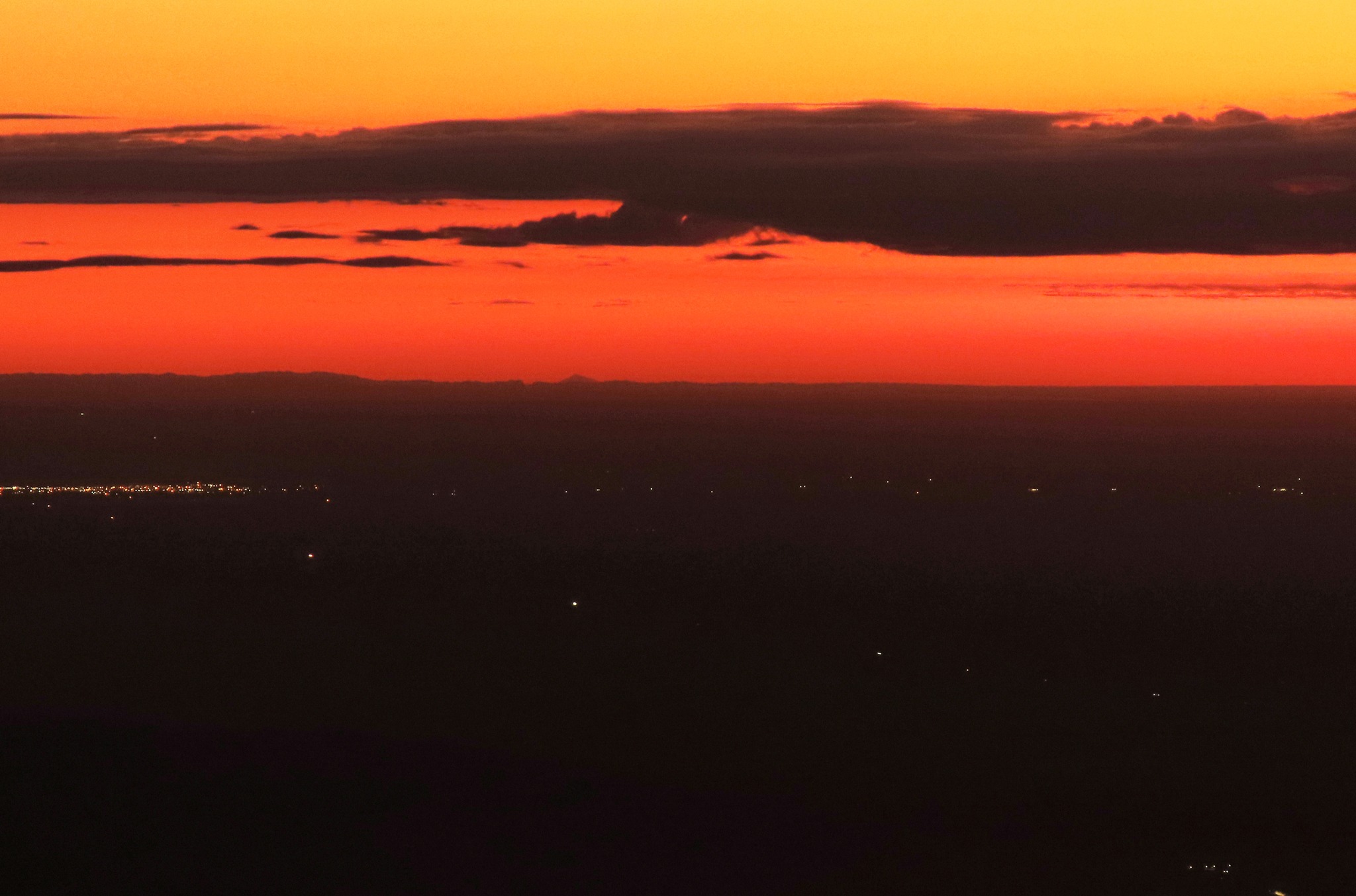
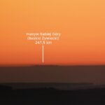
In mid-July 2025, Roberto Antezana again photographed Aconcagua from near Córdoba, setting a new world record of 484.5 km. This was possible because the mountain’s southern summit was visible.
🆕 Aktualizacja wpisu – lipiec 2025 – 484,5 km
🆕 Post update – July 2025 – 484,5 km
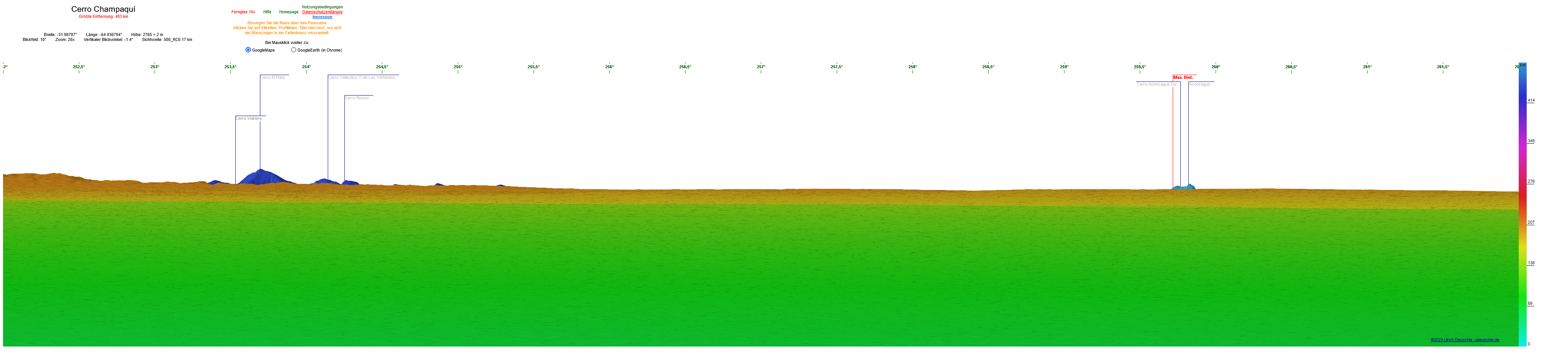
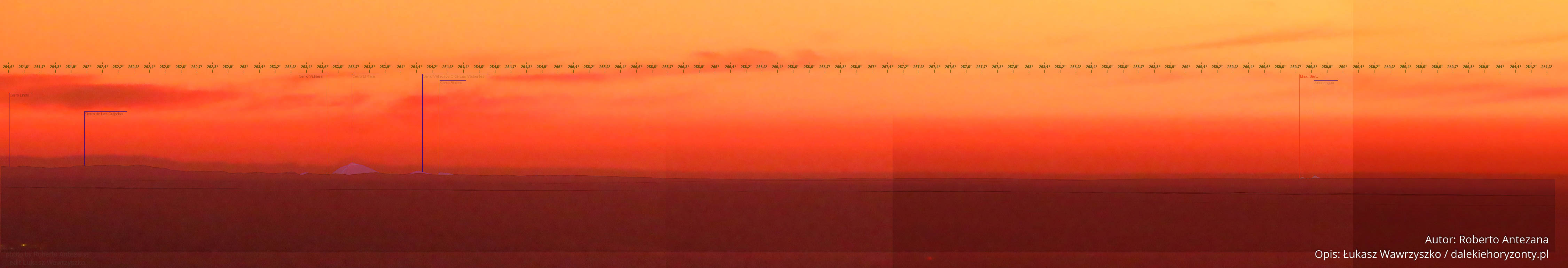
The photos depict: Andes, Aconcagua and the Cordon del Plata mountain range.
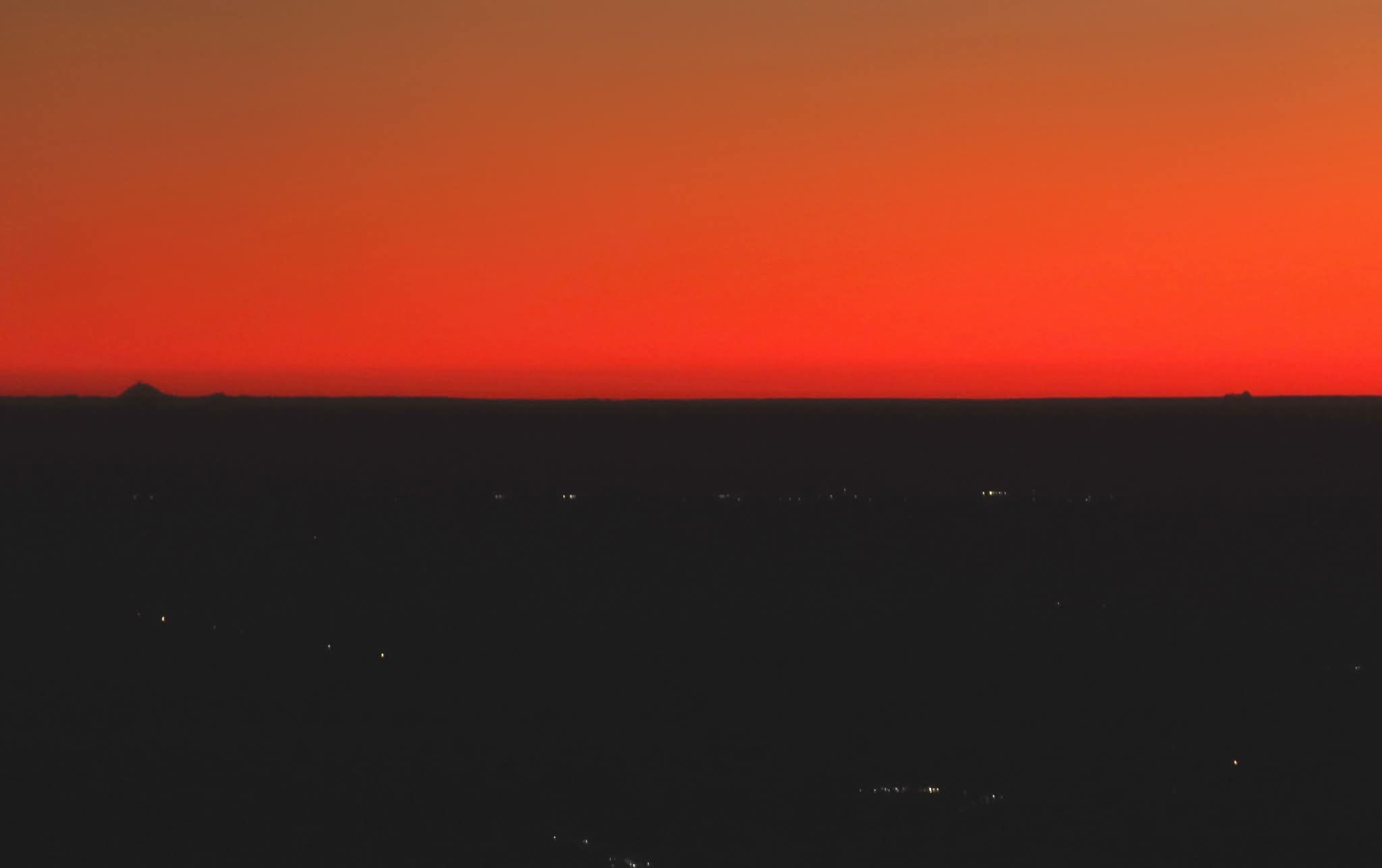
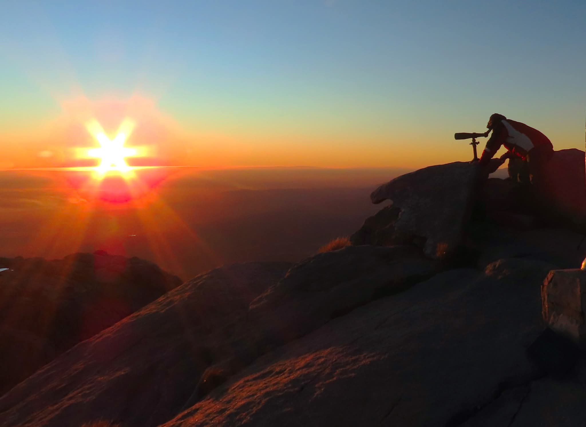
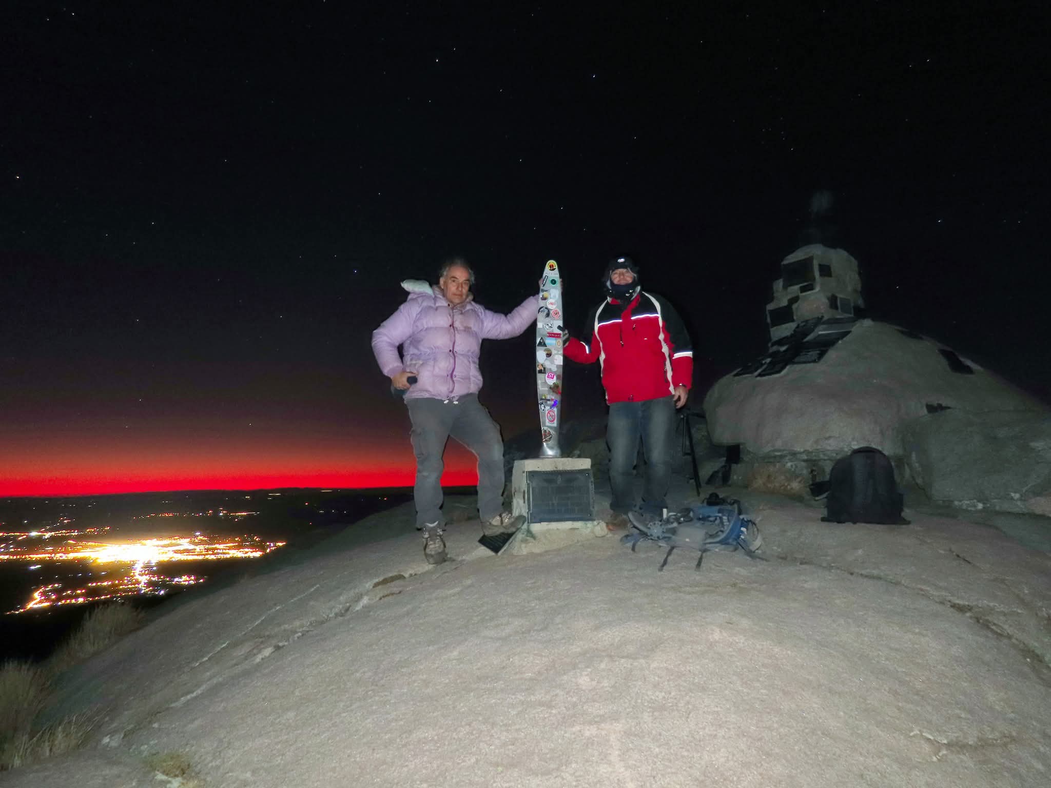
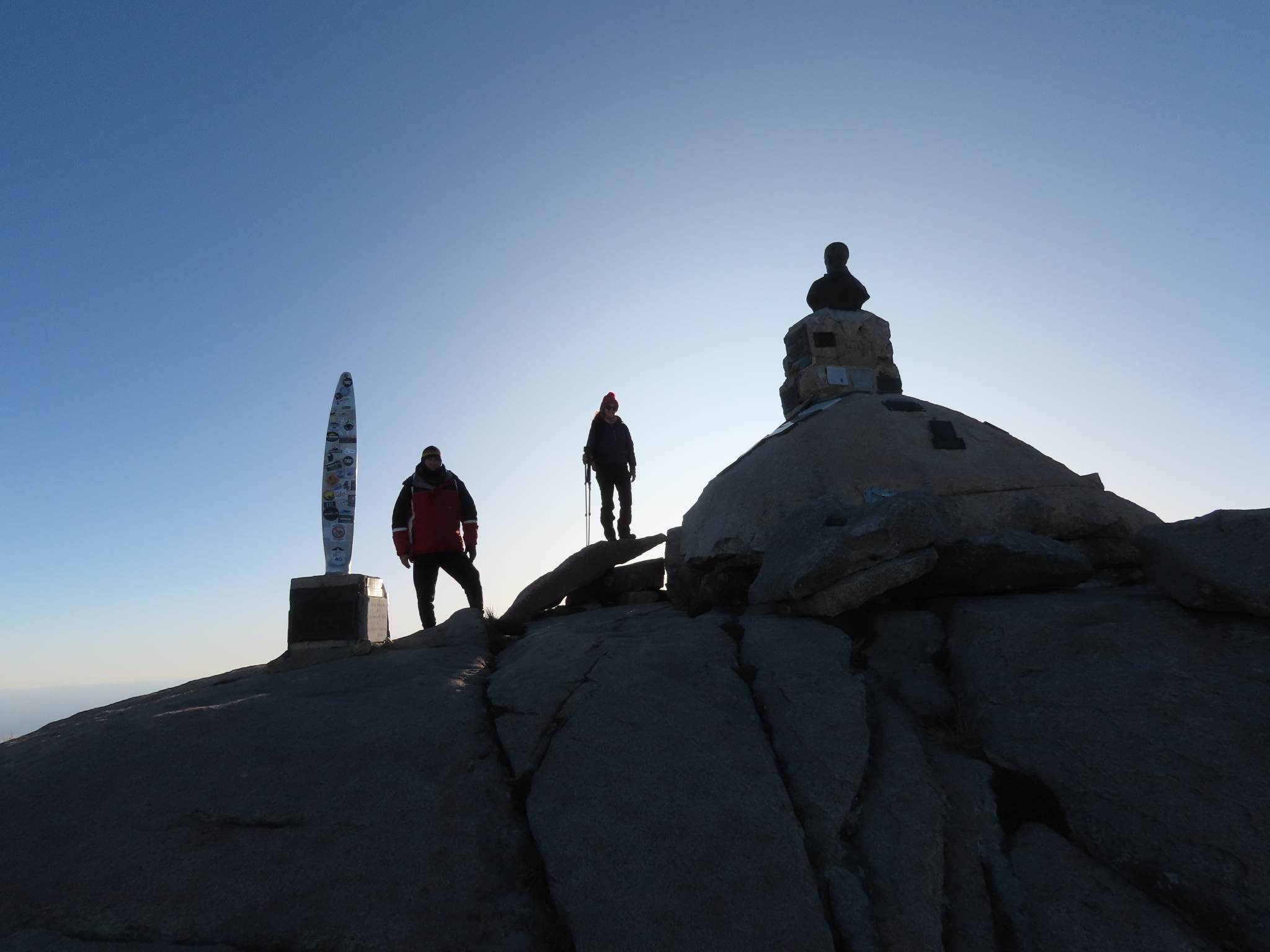
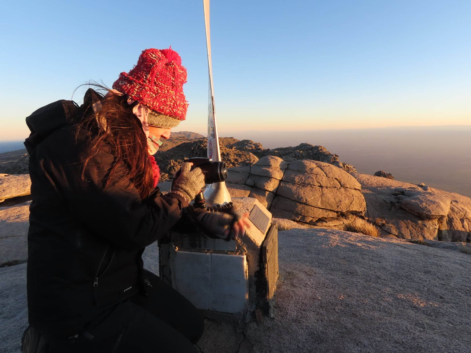
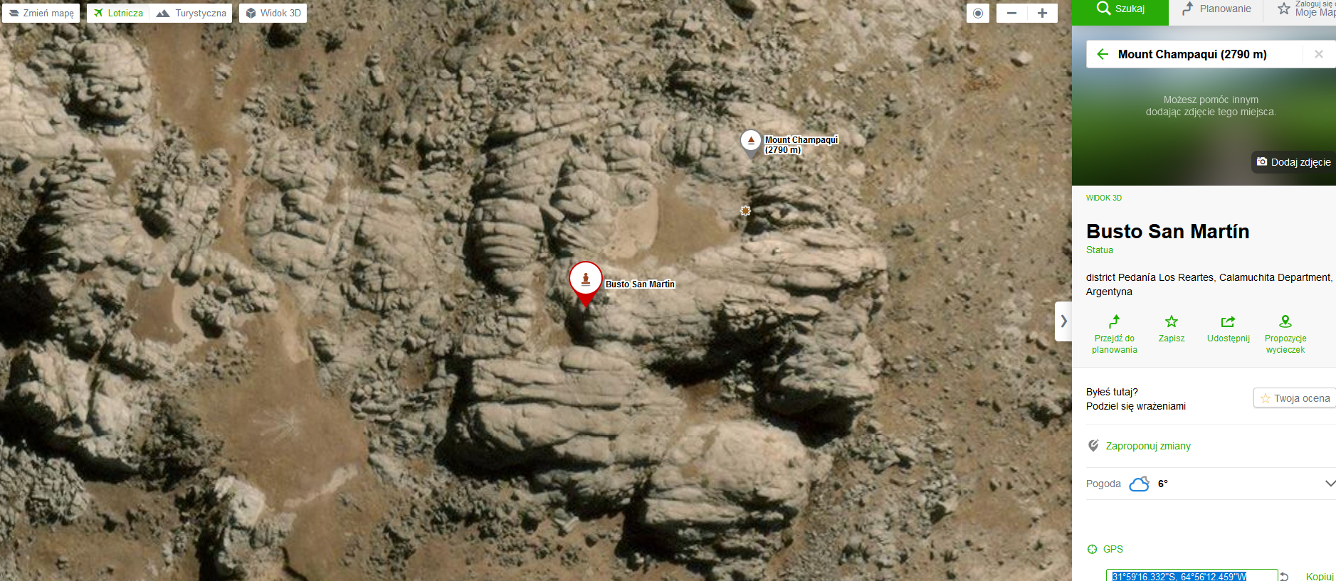
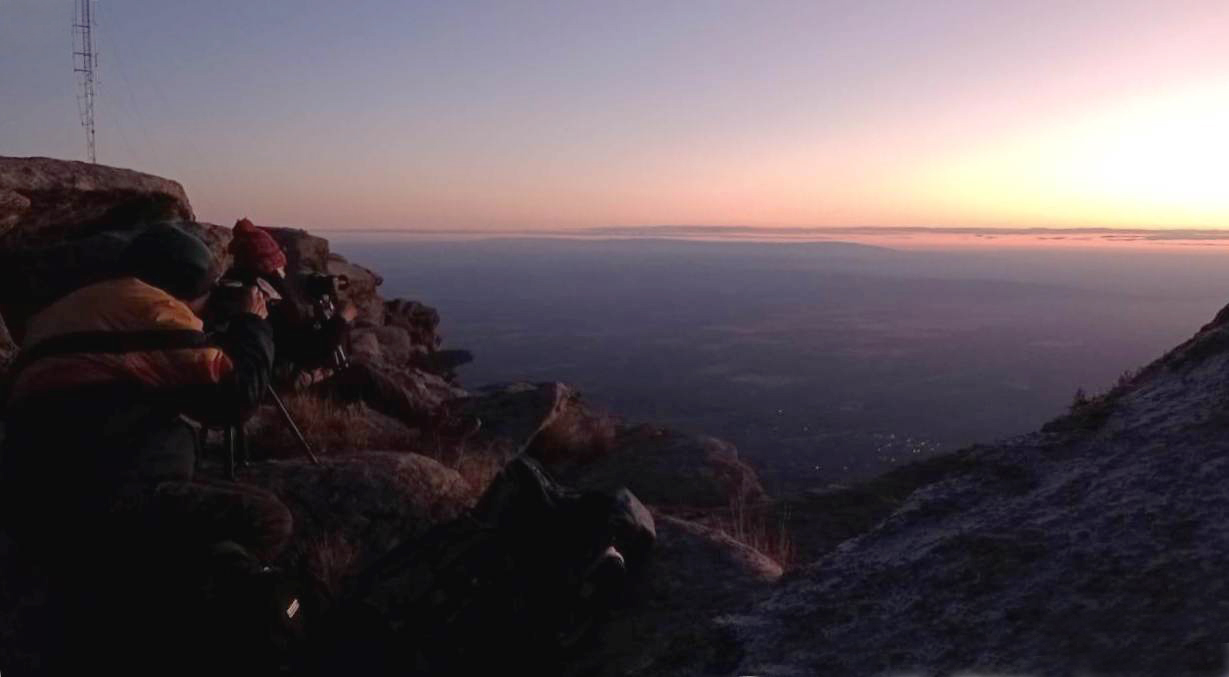
Location: Cerro Champaquí 31°59’16.332″S, 64°56’12.459″W Sierras de Córdoba mountain range, Argentina.
Observer’s elevation: 2770 meters above sea level
Distances: Aconcagua Cumbre Sur – 484,5 km (WGS84 model)
Dates: July 17, 2025
Authors: Roberto Antezana
Equipment: Roberto – Canon SX70 H ; Nikon P900
Description: Record-breaking observation from Argentina.
🌍 Nowy rekord świata! Aconcagua sfotografowana z odległości 484,5 km
🌍 New World Record! Aconcagua photographed from a distance of 484.5 km
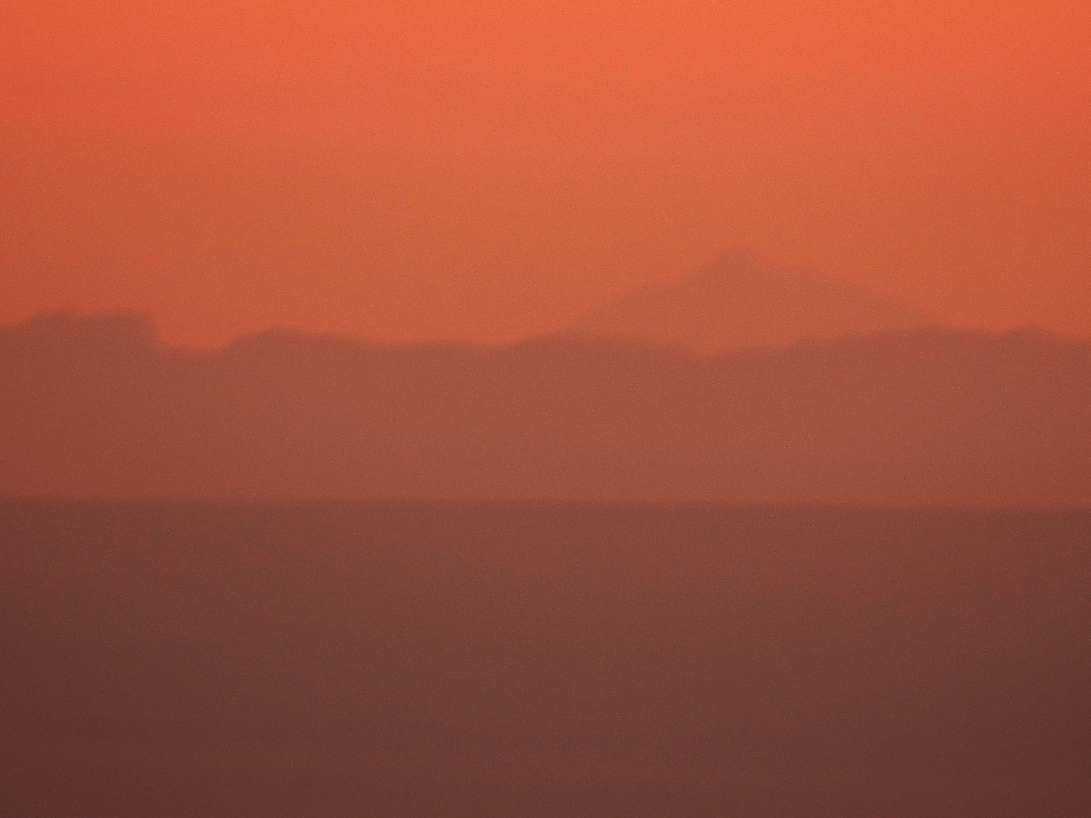
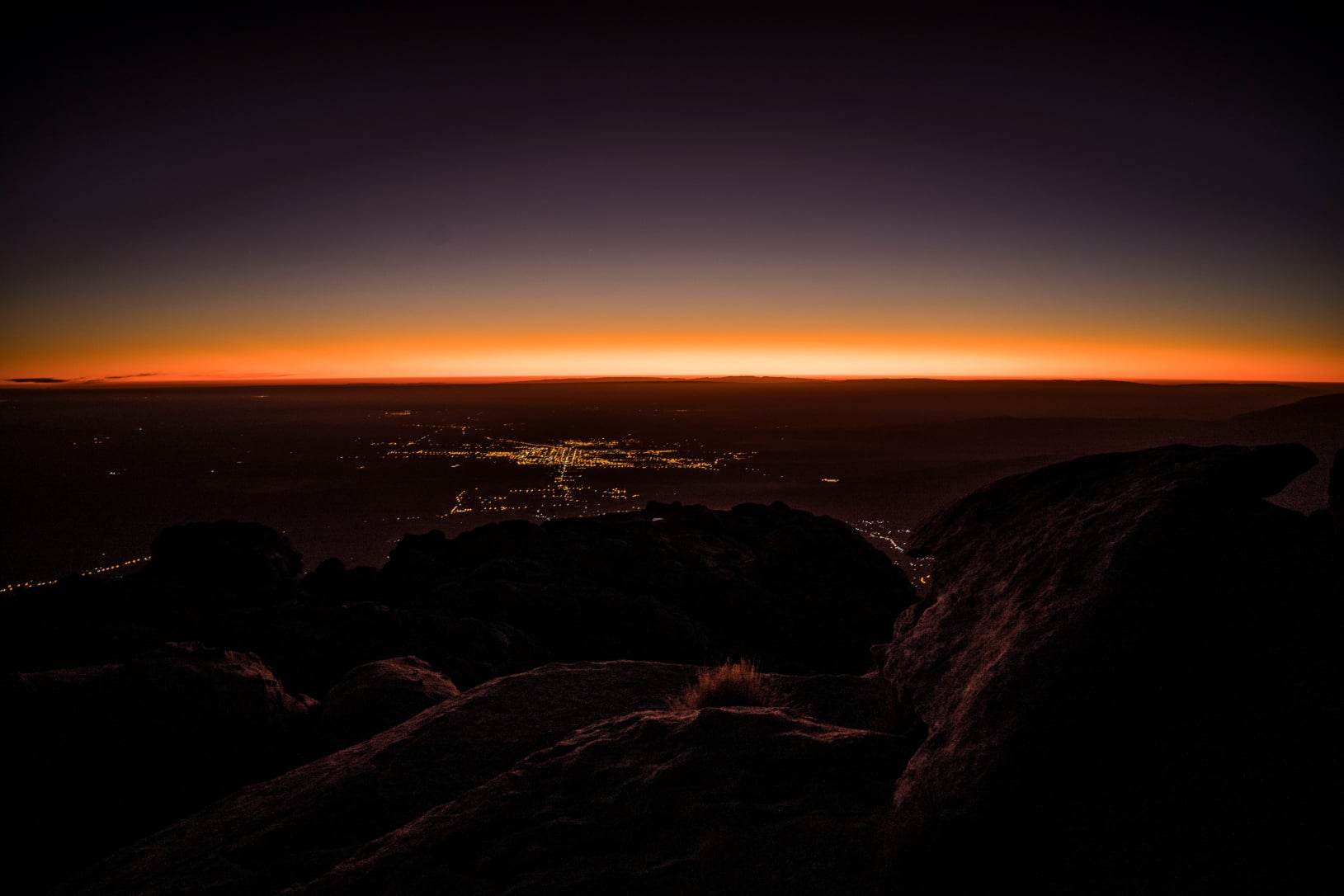
17 lipca 2025 roku padł nowy rekord świata w dziedzinie dalekich obserwacji naziemnych. Podczas wyjątkowo sprzyjających warunków pogodowych chilijski pasjonat Roberto Antezana po raz kolejny przekroczył granicę 480 km. Ze szczytu Cerro Champaquí w argentyńskiej prowincji Córdoba udało mu się sfotografować najwyższy szczyt Ameryki Południowej – Aconcaguę (6962 m n.p.m.), a także, wskutek zwiększonej refrakcji atmosferycznej, jej południowy wierzchołek, Cumbre Sur, co pozwoliło ustalić rekord na odległość 484,5 km.
On July 17, 2025, a new world record was set in the field of long-distance terrestrial observations. During exceptionally favorable weather conditions, Chilean enthusiast Roberto Antezana once again surpassed the 480 km mark. From the summit of Cerro Champaquí in Córdoba Province, Argentina, he managed to photograph South America’s highest peak – Aconcagua (6962 m a.s.l.) – and also, due to increased atmospheric refraction, its southern summit, Cumbre Sur, which set the record at a distance of 484.5 km.
Zdjęcia wykonano aparatami Nikon P900 (ogniskowa 3000 mm) oraz Canon Powershot SX70 HS (1350 mm). Za logistykę całej operacji odpowiadał Ricky Martínez – wieloletni współpracownik autora.
The photos were taken using a Nikon P900 (3000 mm focal length) and a Canon Powershot SX70 HS (1350 mm). The logistics of the entire operation were handled by Ricky Martínez – a longtime collaborator of the author.
🌤️ Warunki pogodowe
🌤️ Weather conditions
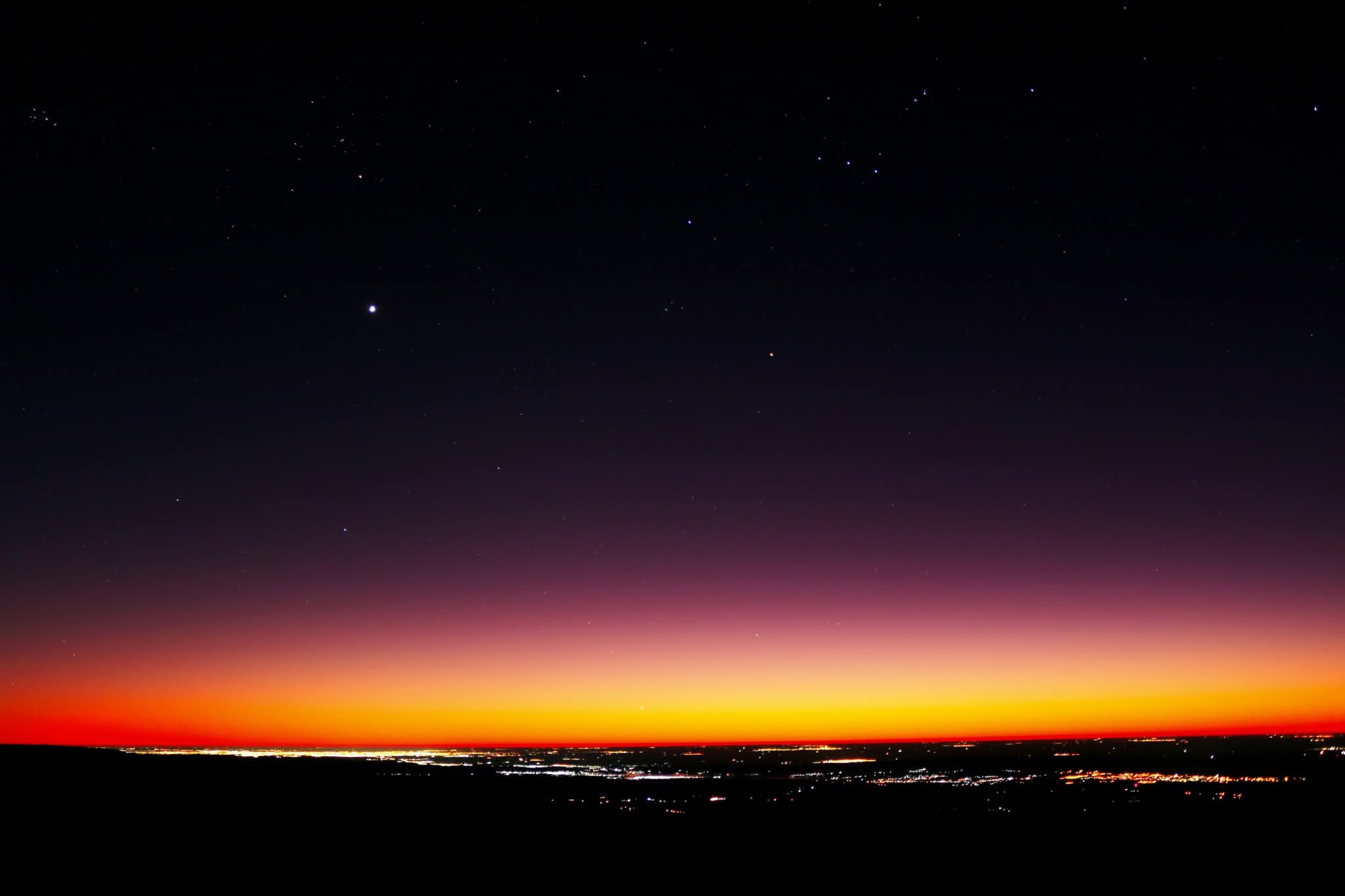
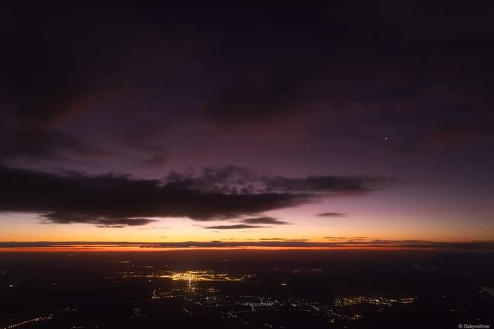
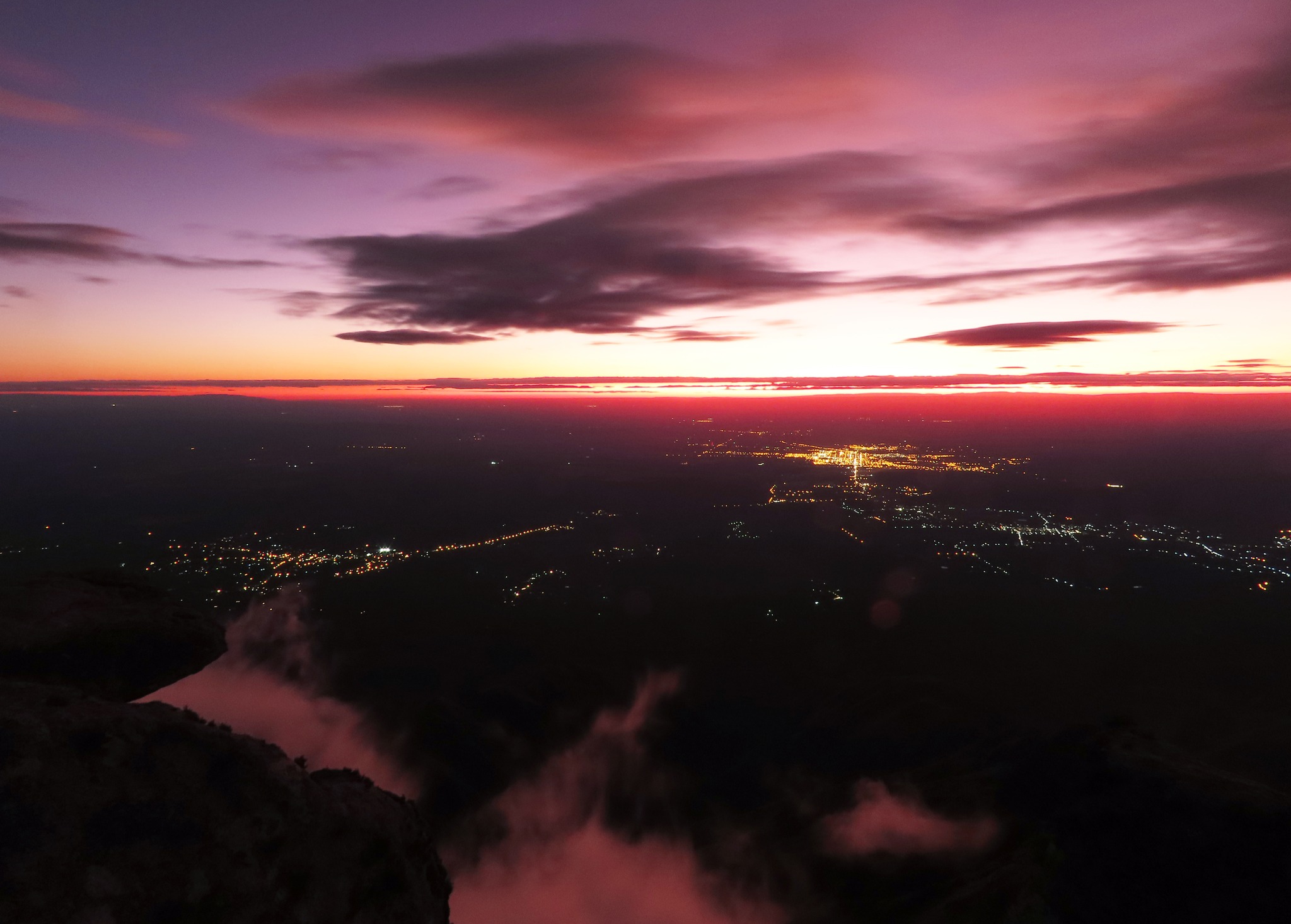
Wyprawa, która zakończyła się rekordową obserwacją, przebiegła w niemal idealnych warunkach: czterodniowe okno pogodowe bez ani jednej chmury, doskonała przejrzystość powietrza i idealne oświetlenie.
The expedition that led to the record-breaking observation took place under nearly perfect conditions: a four-day weather window without a single cloud, excellent air clarity, and perfect lighting.
⛰️ Historia rekordu świata w dalekich obserwacjach naziemnych
⛰️ History of the world record in long-distance terrestrial observations
Przez wiele lat światowy rekord w tej dziedzinie należał do Marca Breta, który w 2016 roku uchwycił Pic Gaspard z gór Finestrelles w Pirenejach. Uzyskany dystans 443 km był przez długi czas nieosiągalnym celem dla innych fotografów – symbolicznie wyznaczał granice możliwości fotografii krajobrazowej.
Przełom nastąpił dopiero w 2023 roku, kiedy Roberto Antezana razem z Gabriellą Vollmer po raz pierwszy sfotografował Aconcaguę z Cerro Champaquí z odległości 483,5 km. Tym razem warunki były jeszcze lepsze niż przy pierwszej udanej obserwacji (483,5 km), którą możecie zobaczyć na naszej stronie (link w komentarzu). Tym razem pojawił się wierzchołek południowy Aconcagui – Cumbre Sur, co zwiększa odległość Rekordu Świata 🌍 do 484,5 km!
For many years, the world record in this field belonged to Marc Bret, who in 2016 captured Pic Gaspard from the Finestrelles Mountains in the Pyrenees. The achieved distance of 443 km remained an unattainable goal for other photographers for a long time – symbolically marking the limits of landscape photography.
The breakthrough came in 2023, when Roberto Antezana, together with Gabriella Vollmer, first photographed Aconcagua from Cerro Champaquí at a distance of 483.5 km. This time, the conditions were even better than during the first successful observation (483.5 km), which you can see on our website (link in the comments). This time, the southern summit of Aconcagua – Cumbre Sur – became visible, extending the World Record 🌍 distance to 484.5 km.
—
🔭 Blisko rekordu… z Turcji!
🔭 Close to the record… from Turkey!
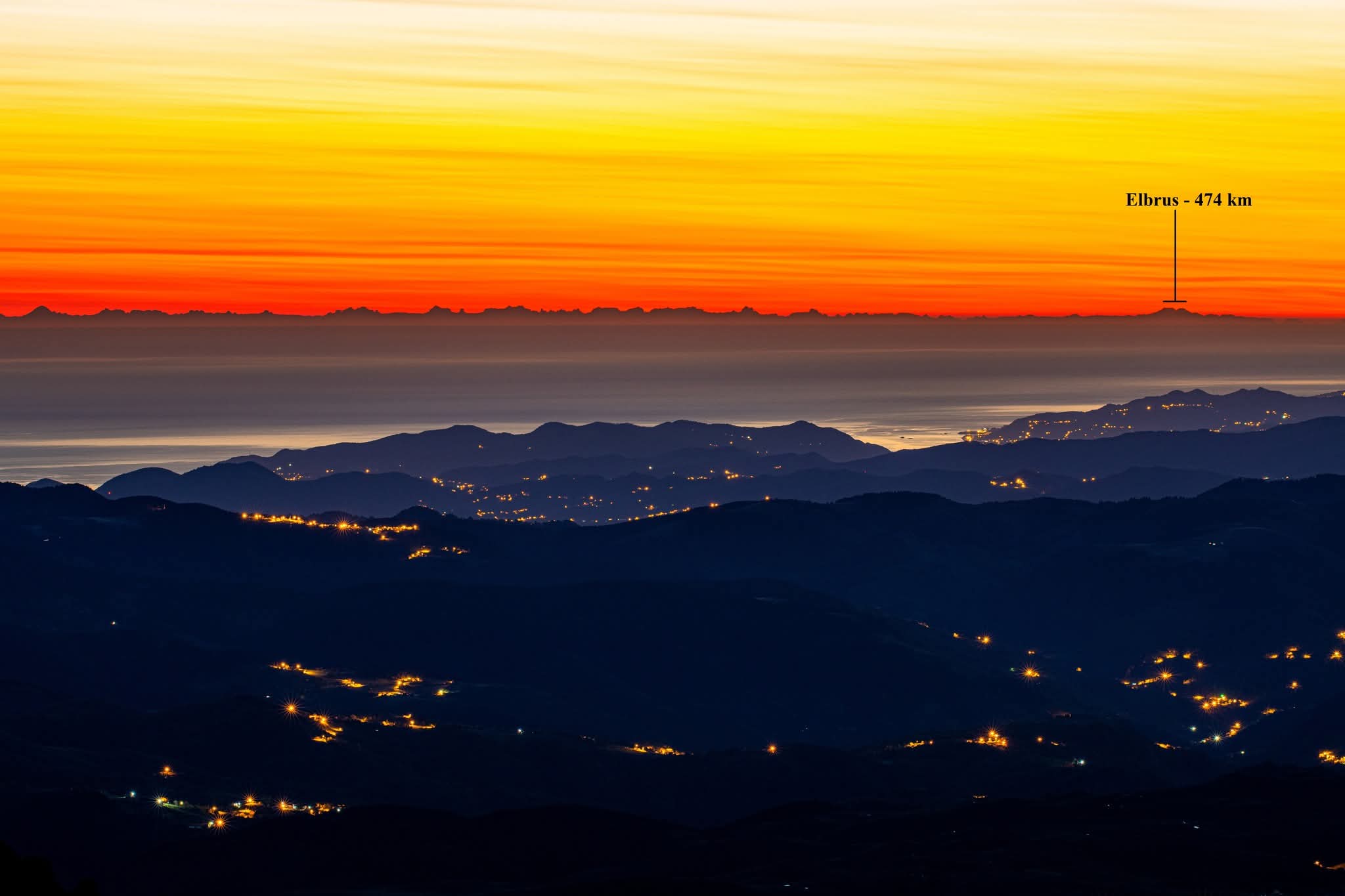
Zaledwie kilka tygodni przed oficjalnym ogłoszeniem nowego rekordu, Richard Ježík dokonał spektakularnej obserwacji z Turcji. Ze szczytu Karagöl udało mu się sfotografować potężny Elbrus, najwyższy szczyt Kaukazu, z odległości 474 km. To drugi wynik w historii światowej fotografii dalekiego zasięgu – zaledwie 10 km za rekordem świata!
Just a few weeks before the official announcement of the new record, Richard Ježík made a spectacular observation from Turkey. From a summit Karagöl, he managed to photograph the mighty Elbrus, the highest peak of the Caucasus, from a distance of 474 km. This is the second-longest distance in the history of global long-distance photography – just 10 km short of the world record!
📂 Relacja archiwalna – sierpień 2023 – 483,5 km
📂 Archive report – August 2023 – 483,5 km
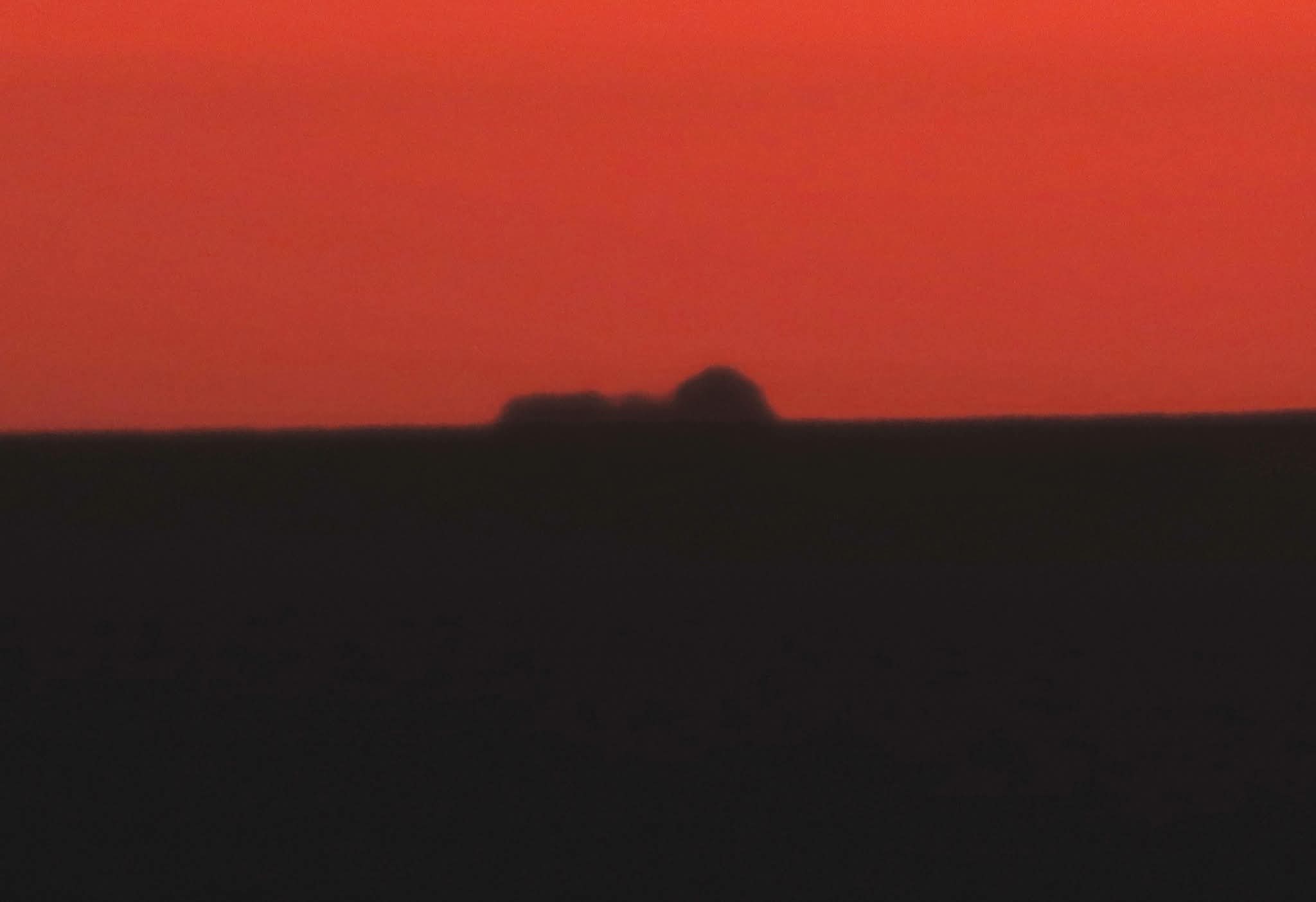
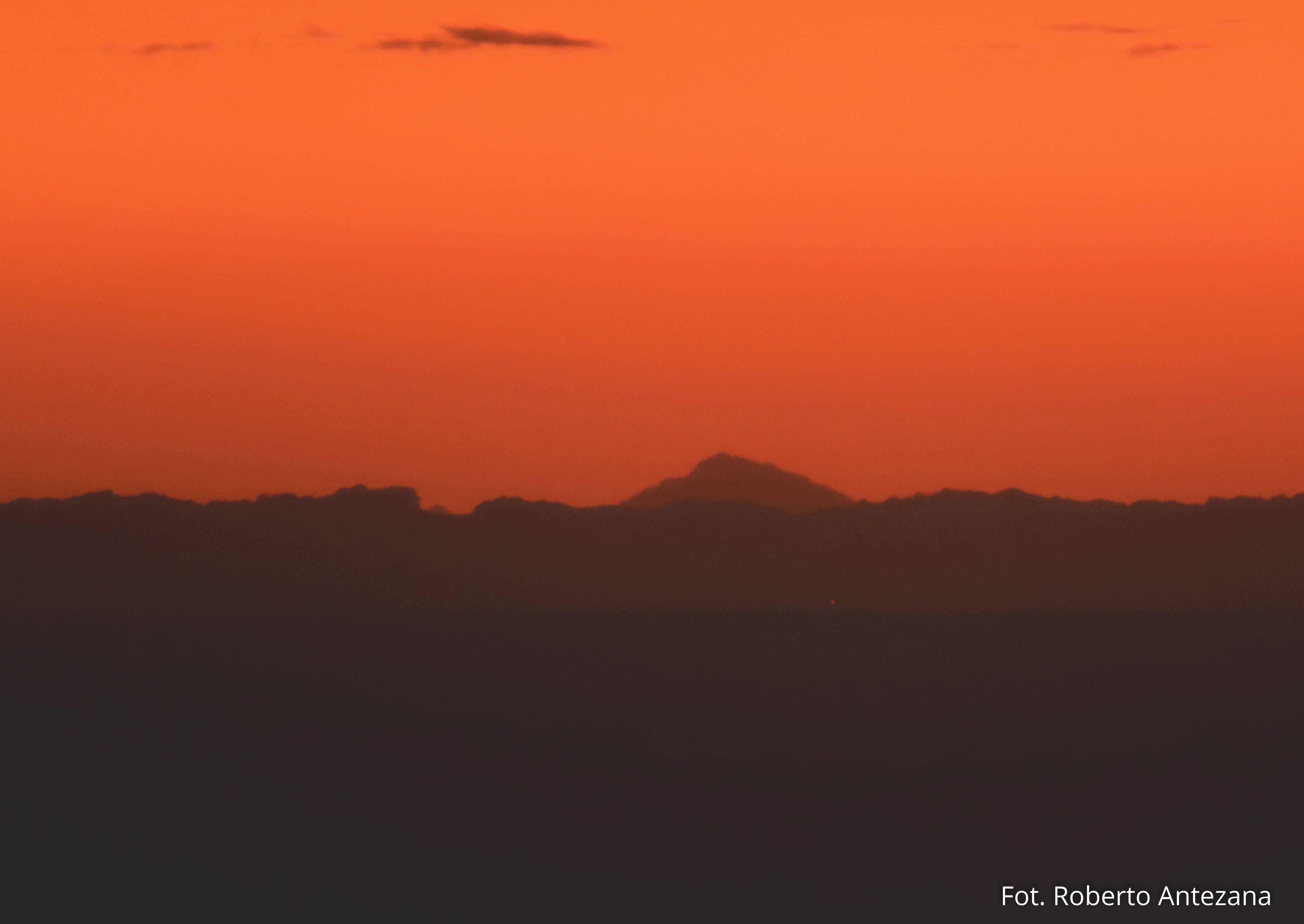
Poniższy fragment pochodzi z pierwszej udanej obserwacji Aconcagui z Cerro Champaquí, wykonanej w sierpniu 2023 roku. Było to historyczne wydarzenie – wówczas ustanowiono nowy rekord świata: 483,5 km. Wtedy nie był widoczny położony dalej o 1 km – południowy wierzchołek masywu.
The section below comes from the first successful observation of Aconcagua from Cerro Champaquí, made in August 2023. It was a historic moment – a new world record was set at the time: 483.5 km. At that time, the southern summit of the massif, located 1 km further, was not visible.
The photos depict: Andes, Aconcagua and the Cordon del Plata mountain range.
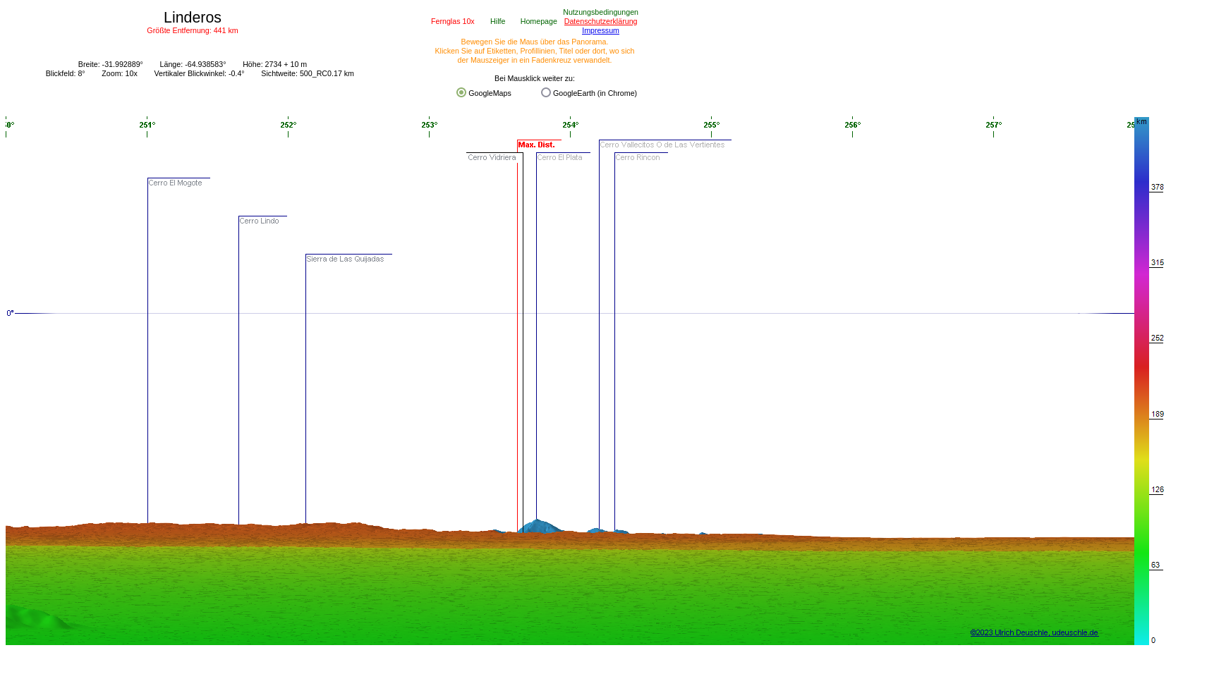
Location: June 13, 2023 (world record) Cerro Champaquí 31°59’16.332″S, 64°56’12.459″W ; May 4, 2023 – point 31°59’34.4″S 64°56’18.9″W on the Cerro Champaquí – Cerro Los Linderos trail in the Sierras de Córdoba mountain range, Argentina.
Observer’s elevation: June 13, 2023 (world record) – 2770 meters above sea level ; May 4, 2023 – 2734 meters above sea level.
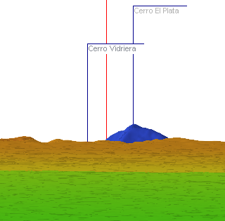
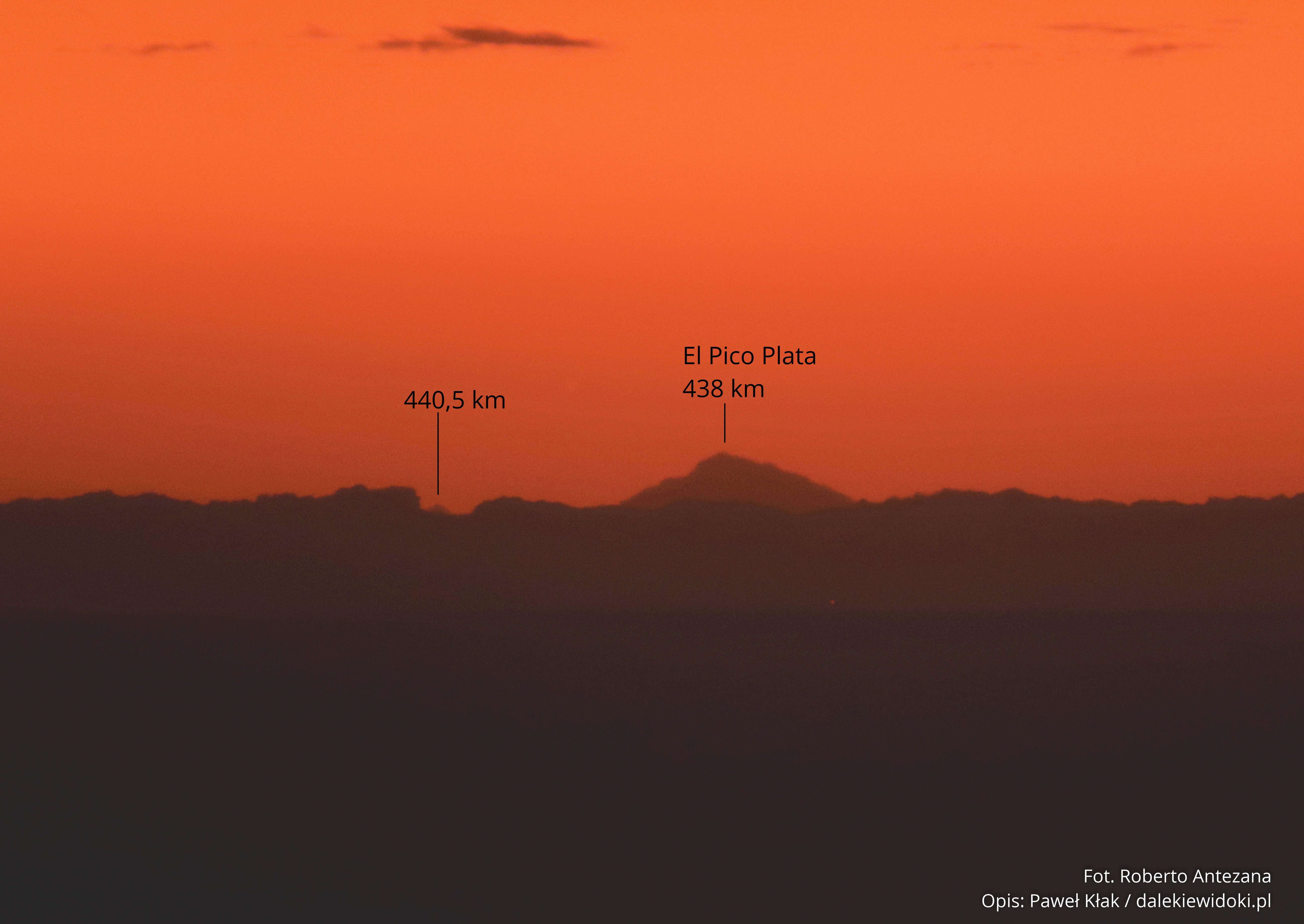
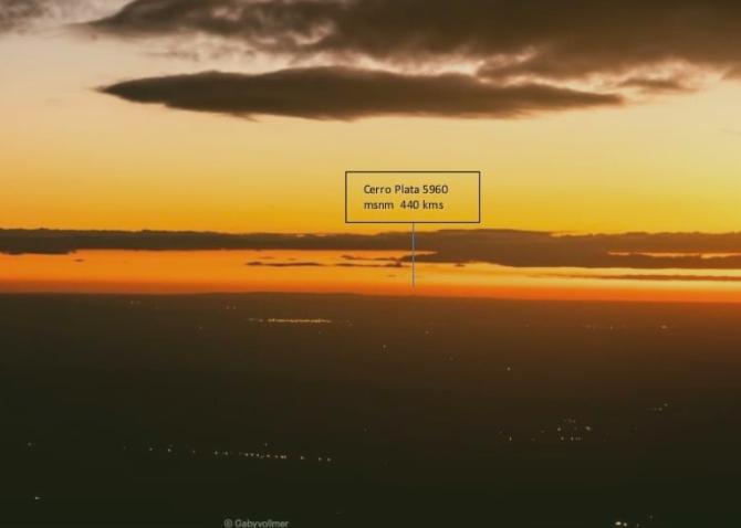
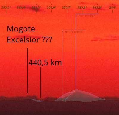
Distances: Aconcagua – 483,5 km (WGS84 model) ; peak (elevation 5441 m) (33°02’11.5″S 69°28’16.8″W) near the El Pico Plata massif – 440.5 km, El Pico Plata – 438 km.
Dates: May 4, 2023, and June 13, 2023 (world record).
Authors: Roberto Antezana and Gabriela Vollmer.
Equipment: Roberto – Canon SX70 HS, Gabriela Vollmer – Canon Eso R Mirrorless 24-105 mm.
Description: Record-breaking observation from Argentina! Is it a Ground – Based Long-Distance Observation World Record !
- English – Observation report from June 13, 2023 (world record – Aconcagua 483,5 km).
- Polski – opis obserwacji z 13 czerwca 2023 (rekord świata – Aconcagua 483,5 km)
- English – Observation report from May 04, 2023 (El Plata 438 km).
English – Observation report from June 13, 2023 (world record – Aconcagua 483,5 km).
May 4, 2023 – (account continued in the following post) – Roberto and Gabriela came close to breaking the world record. They fell short by 2.5 km. Over a month later, they returned to Argentina near the Cerro Champaquí – Cerro Los Linderos trail in the Sierras de Córdoba mountain range, Argentina.
On June 13, Roberto and Gabriela made another attempt to photograph the Aconcagua peak from a distance of 483 km. The conditions along the observation line were favorable: low humidity, no dust, and a clear sky.
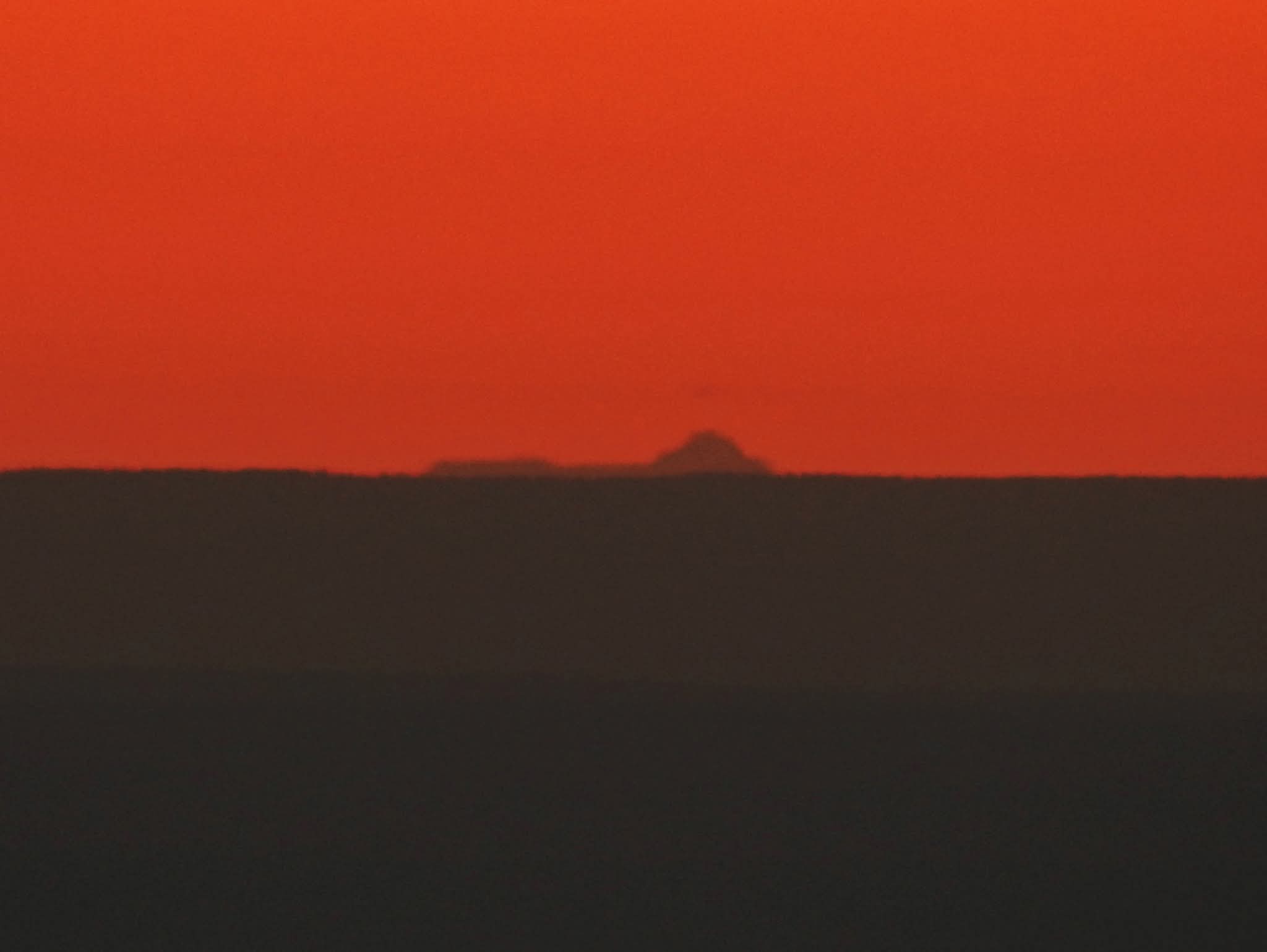
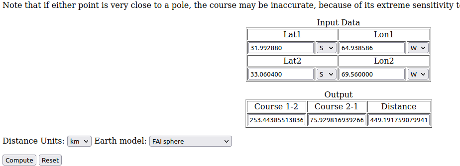
Gabriela Vollmer describes the event as follows: „Finally, an absolute world record in long-distance photography! It’s 483 km. A tremendous distance from the Champaquí hill in Córdoba to the peak of Aconcagua. A true feat at -6 degrees below zero and with a wind speed of 40 km/h at dusk on June 13, 2023!”
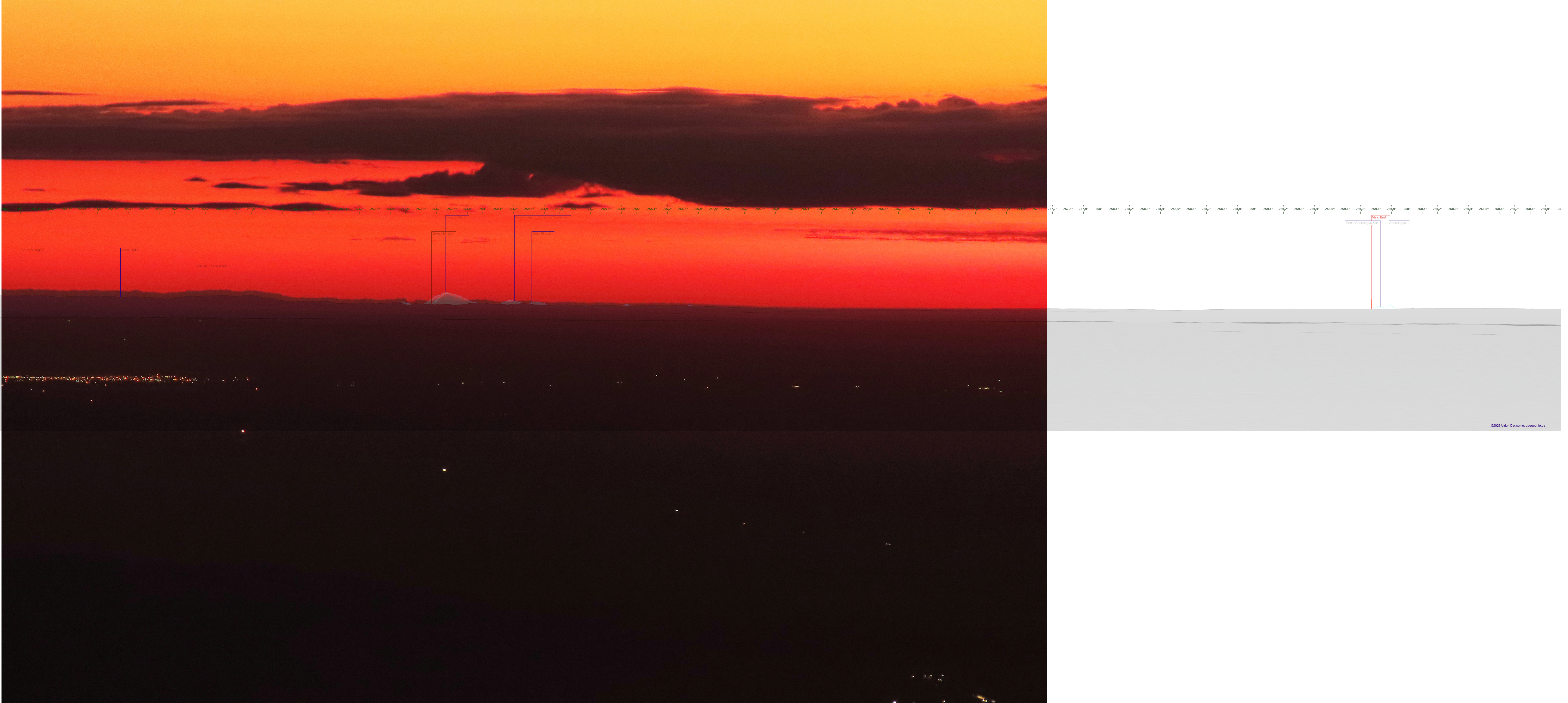
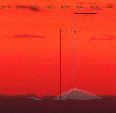
Roberto Antezana : ” I am Roberto Antezana, an astrophotographer and technical astronomer at the University of Chile, and also Gabriela Vollmer, a landscape and nature photographer. The photographs were taken at the summit of Cerro Champaqui on Tuesday, June 13, 2023, at 18:45 Argentine time, in the province of Córdoba. We managed to capture Aconcagua. The distance is enormous – 483 km. Therefore, only a very faint silhouette corresponding to the last meters of the summit of the mentioned mountain is visible. The photographic equipment used to capture Aconcagua: Canon Powershot SX70HS with a maximum zoom of 1365 mm. Author: Roberto Antezana. The panoramic photographic equipment: Canon Eos R 24-105 mm. Author: Gabriela Vollmer. The photographic equipment used to compare the weak image of the last meters of Plata with the last meters of Aconcagua: Nikkor 83x with 24,2000 mm. Author: Gabriela Vollmer. History: In May of this year, we made the first trip with the intention of capturing Aconcagua. Unfortunately, we encountered a delay at that time and were unable to reach the summit of Cerro Champaqui. Instead, we managed to increase the distance to an extension of Cerro Plata at 440.5 km from Cerro Linderos, which has already been published.In June, we had a second opportunity with good weather conditions and traveled to Córdoba, Argentina, to have more time at Champaqui. On the same day, we achieved the farthest observation in the world from one land to another, surpassing the curvature of the Earth. The weather conditions were demanding, with a temperature of -6 degrees Celsius and wind speeds of 30 km/h, gusting up to 40 km/h.We would like to thank Riki Martinez and Cristian Avalos for their support and logistics.”
The distance between an observation site and Aconcagua on Google Maps is 483 km.
Photoreport: Exploring the World Record Through the Lens
ACONGAGUA AND NEW WORLD RECORD.
Verification. The authors do not have a single photo that includes both Plata and Aconcagua. Such a photo would significantly facilitate the verification process, as it would allow for measuring the distance between the peaks in the image and comparing it to the difference in azimuths between the peaks. Having only a photo of Aconcagua alone does not allow for a definitive verification. Fortunately, Roberto has sent a video to the editors of dalekiehoryzonty.pl and dalekiewidoki.pl, which includes both peaks. The video can be divided into frames and stitched together to create a panorama onto which azimuth grids can be overlaid. Such an analysis was conducted by Łukasz Wawrzyszko, an expert in object identification. Although not a precise method, it is the only one that can be used in this case. The arrangement of the peaks in the panorama is correct. Therefore, we can confirm a NEW WORLD RECORD in ground-based long-distance observations.
Congratulations to the authors for this incredible achievement.
Polski – opis obserwacji z 13 czerwca 2023 (rekord świata – Aconcagua 483,5 km)
Zdjęcia przedstawiają: Andy, Aconcagua oraz łańcuch górski Cordon del Plata
Miejsce: 13.06.2023 (rekord świata) – Cerro Champaquí 31°59’16.332″S, 64°56’12.459″W oraz 04.05.2023 – punkt 31°59’34.4″S 64°56’18.9″W przy szlaku Cerro Champaquí – Cerro Los Linderos w paśmie górskim Sierras de Córdoba , Argentyna.
Wysokość obserwatora: 13.06.2023 – 2770 04.05.2023 2734 m.n.pm.
Odległość: Aconcagua – – 483 km (WGS84 model) ; szczyt ( wys. 5441 m) (33°02’11.5″S 69°28’16.8″W) w pobliżu masywu El Pico Plata – 440,5 km , El Pico Plata – 438 km
Czas: 04.05.2023 oraz 13.06.2023 (rekord świata)
Autor: Roberto Antezana Gabriela Vollmer
Sprzęt: Canon SX70 HS – Roberto, Gabriela Vollmer – Canon Eso R Mirrorles 24-105 mm
Opis: Rekordowa obserwacja z Argentyny! Jest Rekord Świata w Dalekich Obserwacjach Naziemnych!
4 maja 2023 – (relacja na stronie) – Roberto i Gabriela otarli się o rekord świata. Zabrakło wtedy 2,5 km. Ponad miesiąc później udali się ponownie do Argentyny w pobliże szlaku Cerro Champaquí – Cerro Los Linderos w paśmie górskim Sierras de Córdoba , Argentyna.
Dokładnie 13 czerwca Roberto i Gabriela ponowili próbę sfotografowania szczytu Aconcagua z dystansu 483. Warunki panujące na linii obserwacji były sprzyjające : niska wilgotność, brak pyłów i bezchmurne niebo. Tak zdarzenie opisuje Gabriella Vollmer: „Nareszcie absolutny rekord świata w fotografii na odległość ! To 483 km. Ogromna odległość od wzgórza Champaqui w Cordobie do szczytu góry Aconcagua. Prawdziwy wyczyn przy -6 stopni poniżej zera i wietrze z prędkością 40 kmh. o zmierzchu 13 czerwca 2023!”
Opis Roberto: ” Jestem Roberto Antezana, astrofotografem i technicznym astronomem na Uniwersytecie Chile, a także Gabriela Vollmer, fotografem pejzażu i natury. Zdjęcia zostały wykonane na szczycie Cerro Champaqui w dniu wtorek, 13 czerwca 2023 roku, o godzinie 18:45 czasu argentyńskiego, w prowincji Córdoba. Udało nam się uchwycić Aconcaguę. Odległość jest ogromna – 483 km. Dlatego też widoczna jest tylko bardzo słaba sylwetka, odpowiadająca ostatnim metrom szczytu wspomnianej góry. Sprzęt fotograficzny użyty do uchwycenia Aconcagui: Canon Powershot SX70HS z maksymalnym zoomem 1365 mm. Autor: Roberto Antezana. Sprzęt fotograficzny do panoramy: Canon Eos R 24-105 mm. Autorka: Gabriela Vollmer. Sprzęt fotograficzny użyty do porównania słabego obrazu ostatnich metrów Platy z ostatnimi metrami Aconcagui: Nikkor 83x z 24,2000 mm. Autorka: Gabriela Vollmer. Historia: W maju tego roku odbyliśmy pierwszą podróż z zamiarem uchwycenia Aconcagui. Niestety, wtedy napotkaliśmy opóźnienie i nie udało nam się dotrzeć na szczyt Cerro Champaqui. Zamiast tego udało się nam zwiększyć odległość – obserwacja Cerro Plata na 440,5 km od Cerro Linderos, co już zostało opublikowane. W czerwcu mieliśmy drugą okazję z dobrymi warunkami pogodowymi i udaliśmy się do Córdoby, Argentyny, aby mieć więcej czasu na Champaqui. Tego samego dnia udało się nam osiągnąć najdalszą naziemną obserwację na świecie , przekraczając krzywiznę ziemi. Warunki pogodowe były wymagające, temperatura wynosiła -6 stopni Celsiusza, a wiatr osiągał prędkość 30 km/h, z porywami do 40 km/h. Chcielibyśmy podziękować Rikiemu Martinezowi i Cristianowi Avalosowi za wsparcie i logistykę.”
ACONGAGUA – NOWY REKORD ŚWIATA.
📂 Relacja archiwalna – sierpień 2023 – 440,5 km
📂 Archive report – August 2023 – 440,5 km
English – Observation report from May 04, 2023 (El Plata 438 km). REPORT FROM THE FIRST ATTEMPT TO BREAK THE RECORD 04/05/2023
On May 4, 2023, Roberto Antezana and Gabriela Vollmer embarked on a journey to the Cerro Champaquí massif, the highest peak in the province of Córdoba, Argentina. Their goal was to attempt the World Record for long-distance ground-based observation. The previous record to beat was 443 km – the observation record of Pic Gaspard in the Alps from the Pyrenees. The targets were to capture Aconcagua at 483 km or Mogote Excelsior at 449 km, located near El Pico Plata at 438 km.
Immediately after taking the photos, Roberto Antezana reached out to Dalekiewidoki.pl (Paweł Kłak) and Dalekiehoryzonty.pl (Łukasz Wawrzyszko) for analysis and verification of the potential WORLD RECORD for terrestrial long-distance observations.After a quick analysis, we knew that El Pico Plata (438 km) was clearly visible in the photos. We proceeded with a detailed analysis of the potentially record-breaking peaks. This was challenging due to the quality of the photos – they were taken in strong winds and were blurry. Was there a record?
The photos and a full analysis are presented in the later part of this text. We are publishing these photos with the author’s permission as the first in the world.
Quest for Aconcagua at 483 km in the photos from the first expedition on May 4, 2023 .Unfortunately, after 'stitching’ the photos into a panorama, it turned out that the peak is beyond the range of observation. Additional photos with the correct direction are blurry.
Let’s move on to the analysis of the visibility of another potential summit that could have set a record during the expedition on May 4, 2023 – Mogote Excelsior (distance to it is 449 km), located near El Pico Plata.
Data about the summit was retrieved from https://www.andes-specialists.com/mogote-excelsior/
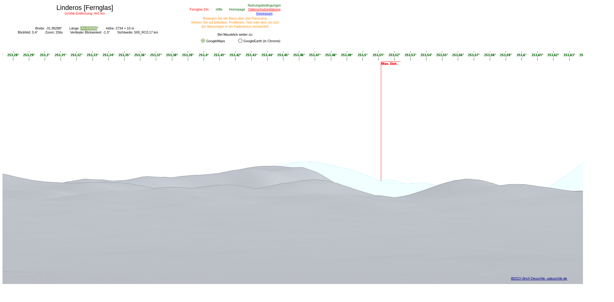
Let’s draw the line of sight between the observer’s point (https://goo.gl/maps/ghVsX3oeWyNHAbtn7) and the summit of Mogote Excelsior. We will use the tool heywhatsthat.com. Here is the link to the simulation: https://www.heywhatsthat.com/?view=MU82WJ59 For standard atmospheric refraction (0.14), the line of sight encounters an obstacle at around 200 km – the elevations near the National Park – 'Parque Nacional Sierra De Las Quijadas. Let’s check if the mentioned summit is visible in the photos, which would mean a world record already achieved on the first expedition on May 4, 2023. We will use the overlaid simulation from the udeutsche.de program. It is visible that at azimuth 235.5, we have the summit’s peak – (elevation 5441 m) (33°02’11.5″S 69°28’16.8″W) near the El Pico Plata massif – 440.5 km. Unfortunately, at azimuth 253.44, there is no prominent summit of Mogote Excelsior. In its position, there is something resembling a mirage of a hill distant by 200 km or simply clouds.
Farthest Landscape ever Recorded, Farthest Landscape World Record, Farthest Line of Sight ever Recorded, Farthest Line of Sight on Earth, Farthest Line of Sight World Record, Farthest Photograph ever Recorded, Farthest Photograph on Earth, Farthest Photograph World Record, Farthest Picture ever Recorded, Farthest Picture on Earth, Farthest Picture World Record, Farthest View ever Recorded, Farthest View on Earth, Farthest View World Record, Longest Landscape ever Recorded, Longest Landscape on Earth, Longest Landscape World Record, Longest Line of Sight ever Recorded, Longest Line of Sight on Earth, Longest Line of Sight World Record, Longest Photograph ever Recorded, Longest Photograph on Earth, Longest Photograph World Record, Longest Picture ever Recorded, Longest Picture on Earth, Longest Picture World Record, Longest View ever Recorded, Longest View on Earth, Longest View World Record, Most Distant Landscape ever Recorded, Most Distant Landscape on Earth, Most Distant Landscape World Record, Most Distant Line of Sight ever Recorded, Most Distant Line of Sight on Earth, Most Distant Line of Sight World Record, Most Distant Photograph ever Recorded, Most Distant Photograph on Earth, Most Distant Photograph World Record, Most Distant Picture ever Recorded, Most Distant Picture on Earth, Most Distant Picture World Record, Most Distant View ever Recorded, Most Distant View on Earth, Most Distant View World Record, Most Extreme Landscape ever Recorded, Most Extreme Landscape on Earth, Most Extreme Landscape World Record, Most Extreme Line of Sight ever Recorded, Most Extreme Line of Sight on Earth, Most Extreme Line of Sight World Record, Most Extreme Photograph ever Recorded, Most Extreme Photograph on Earth, Most Extreme Photograph World Record, Most Extreme Picture ever Recorded, Most Extreme Picture on Earth, Most Extreme Picture World Record, Most Extreme View ever Recorded, Most Extreme View on Earth, Most Extreme View World Record
Wspaniałą obserwacja!
Such a fantastic observation! Now everyone in the world of long-distance observations should be aware of this score! This is another achievement, which pushes the borders towards another unrealistic level.
Cześć.
Z przykrością informuję, że jest mały błąd, jak już powiedziałem Roberto, ale on mnie ignoruje, w lokalizacji Cerro Plata i Aconcagua.
Przesyłam Ci skład mojej analizy, którą wykonałem, aby zweryfikować, czy mam rację.
Jeśli potrzebujesz więcej informacji, nie wahaj się mnie zapytać.
Pozdrowienia.
Tonymelenas@gmail.com
Your analysis contains errors. The easiest way is to connect 3 points in google maps: Observer, Plata, Aconcagua. See which cities the line of sight passes by.
It’s what I’ve done. I’m not new to this. And no, I was not wrong.
Look!!
In 3D
Zapomniałem umieścić kroki.
Well done for dalekiewidoki.pl and dalekiehoryzonty.pl you both appear to be the most informative sources about long-distance observations worldwide!
Directo deste Chile!
Felicitaciones.
The message named from „marcabret” is false, it is a identitiy fraud. Impersonation. The person to whom it is intended to refer has not written it.
So. Please, remove it.
Very good analysis work by Lucasz and the whole DK team. The irregular definition of the spots in the photos, the poor quality of the video and the backward movements of the zoom and change of orientation make it difficult to pinpoint the location of the supposed silhouette and I think that it does not allow to pinpoint its azimuth and the record verification; I would rather wait for future better photographs.
However, I do recognize that the potential margin of error seems very slight and residual and the analysis you have done has been the best option. I myself had also made similar analyzes in many other similar situations with confused relief and very few other references.
In many cases I’ve refrained from publishing something until I have returned to the same site and repeated the photographs in better weather conditions.
Regarding the arrangement of the lights (which I have also analyzed) with respect to the stain, they also seem to be consistent in the frames and in the photographs, and this is in their favor.
Regarding the refractive index, a value of 0.15 is more consistent than the overrepresented 0.17.
In the future, photographs taken in better conditions of refraction and transparency will undoubtedly allow for better photographic results and better verification of what is intended.
We ourselves were about to go in previous years on some occasions because we already knew the possibility (and ease) of achieving it, since I had realized that with such a degree of refraction (much less than that necessary for the case of the Mercedarian, the which was intended to be made to believe that it was instead of Cerro del Plata in 2016) and also very common -from experience- in such circumstances, it was achievable but in the end we expected too much and we’ve been letting opportunities pass, as well as allowing the record to continue in Europe. In any case, it was all a matter of timing, of course.
Beautiful and wonderfull skies of the Argentine and Chilean southern cone!
——
Bardzo dobra praca analityczna Łukasza i całego zespołu DK. Nieregularne zarysowanie plam na zdjęciach, słaba jakość wideo oraz cofanie się zoomu i zmiana orientacji utrudniają namierzenie położenia domniemanej sylwetki i myślę, że nie pozwalają na określenie jej azymutu oraz weryfikacja zapisu; Wolę poczekać na lepsze zdjęcia w przyszłości. Zdaję sobie jednak sprawę, że potencjalny margines błędu wydaje się bardzo niewielki i szczątkowy, a analiza, którą przeprowadziłeś, była najlepszą opcją. Sam również przeprowadzałem podobne analizy w wielu innych podobnych sytuacjach z niejasną ulgą i bardzo niewielką liczbą innych odniesień. W wielu przypadkach wstrzymywałem się z publikacją, dopóki nie wróciłem w to samo miejsce i nie powtórzyłem zdjęć w lepszych warunkach pogodowych. Jeśli chodzi o rozmieszczenie świateł (które też analizowałem) względem plamy, to one również wydają się spójne w kadrach i na fotografiach, co przemawia na ich korzyść. Jeśli chodzi o współczynnik załamania światła, wartość 0,15 jest bardziej spójna niż nadreprezentowana wartość 0,17. W przyszłości zdjęcia wykonane w lepszych warunkach załamania światła i przezroczystości niewątpliwie pozwolą na uzyskanie lepszych efektów fotograficznych i lepszą weryfikację zamierzeń. W poprzednich latach sami jechaliśmy w niektórych przypadkach, ponieważ znaliśmy już możliwość (i łatwość) osiągnięcia tego celu, ponieważ zdałem sobie sprawę, że przy takim stopniu załamania światła (znacznie mniejszym niż konieczny w przypadku Mercedariana, co miało w zamierzeniu wmówić, że jest zamiast Cerro del Plata w 2016 roku) i również bardzo powszechne – z doświadczenia – w takich okolicznościach było to osiągalne, ale ostatecznie oczekiwaliśmy zbyt wiele i puszczaliśmy okazje pass, a także umożliwienie kontynuacji rekordu w Europie. W każdym razie wszystko było oczywiście kwestią czasu. Piękne i cudowne niebo argentyńskiego i chilijskiego południowego stożka!
[…] Fotografia długodystansowa ma na celu uchwycenie obiektu z długiego dystansu. Zazwyczaj tego typu fotografie wykonywane są w warunkach standardowych bo takie występują najczęściej. Do uchwycenia obiektu z daleka często wystarczy „tylko” dobra widzialność i przejrzystość powietrza. Występowanie standardowej refrakcji (o współczynniku 0,13) jest wystarczające na przykład do obserwacji słowackich Tatr z dystansu powyżej 200 km z terenu Polski , ale także And z okolic Cordoby w Argentynie z dystansu 440 km. […]
[…] Long-distance photography aims to capture objects from a great distance. Typically, such photographs are taken under standard conditions because they are most common. To capture an object from a distance, „only” good visibility and air transparency are often enough. Standard refraction (with a coefficient of 0.13) is sufficient, for example, for observing the Slovak Tatra Mountains from a distance of over 200 km from Poland or Andes from the Cordoba region in Argentina at a distance of 440 km. […]
[…] observation that calls the Round Earth model into question is the photo here which was taken in which Wikipedia lists as a world-record on their “Long-distance […]
To jest ten rekord czy nie? Jaka ostatecznie jest odległość? Artykuł podaje chyba 4 różne wersje wydarzen
jest rekord, artykuł podawał opis 2 wypraw – pierwsza była nieudana zabrakło 2,5 km do rekordu , druga była udana. Tekst został lekko poprawiony i dodane odnośniki do każdej z wypraw. teraz jest bardziej czytelny.
[…] nella sezione “Ground-to-ground world records” e anche la pagina https://dalekiewidoki.pl/2023/05/world-record-andes.html dove viene mostrata la foto e spiegati i dettagli […]
[…] long-distance photograph cited by Flat-Earthers is the record 483 km snap. The website here gives an observer height of 2.77 km and an elevation height of the mountain snappped at 5.4 km. The […]
Gratulacje dla Roberto. Tym razem wszystko jest jasne i oczywiste, a do poprzedniego rekordu jeszcze trochę udało się dołożyć. Trudno uwierzyć, ale warunki okazały się jeszcze lepsze!
Impressive distance – congratulations on the world record. It’s great that there’s a place online where such remarkable observations can be shared and appreciated.
I think the name of the summit is Karagöl Dağı. Karagöl means Black Lake, and there are a few lakes in Turkey that are called this.