Tools
Custom-Built Analytical Tools
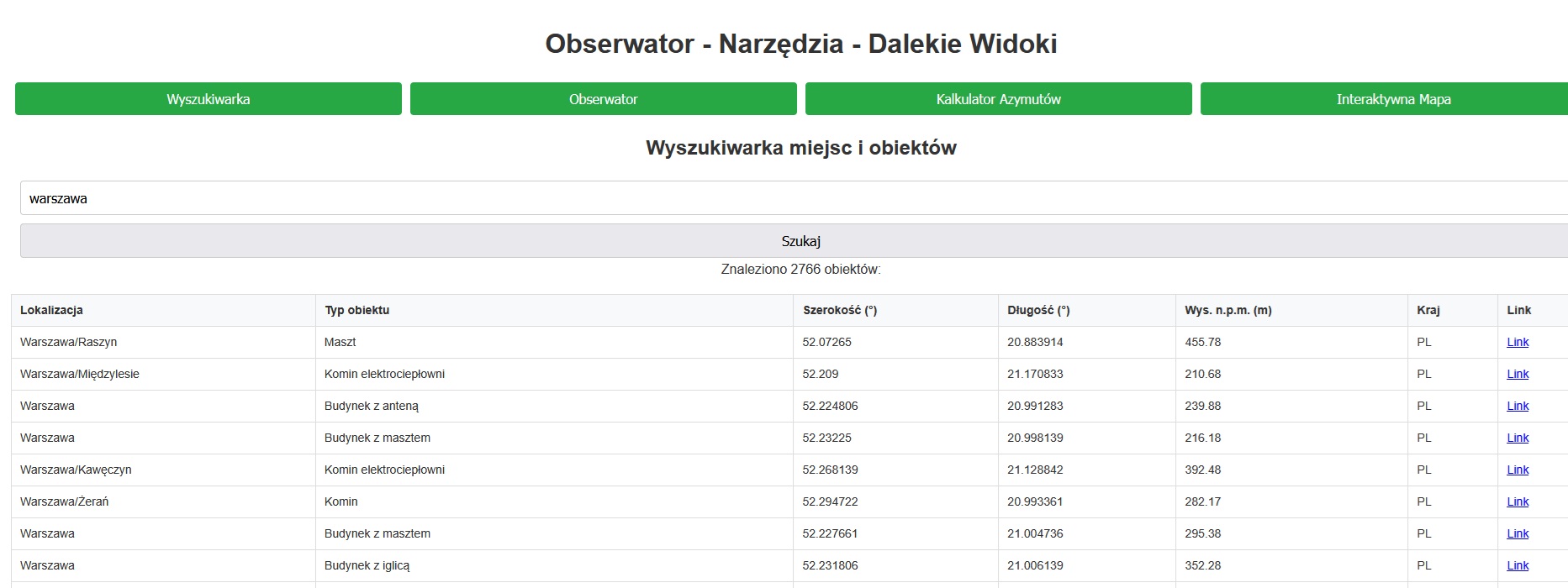
Observer’s Navigator
A tool that integrates an extensive database of geographic and anthropogenic objects with precise calculations, providing support for planning every photographic and observational trip.
Go to the Observer’s Navigator app
Key modules and features:
- Observer’s Point (planning module): Allows you to generate a list of objects within a specified azimuth and distance range. It enables filtering of results (natural objects, structures, objects with lighting).
- Object Database (search engine): Provides data on thousands of objects (peaks, masts, chimneys) from Poland and neighboring countries, allowing for a quick search of their coordinates and altitudes.
- Azimuth and Distance Calculator: A precision tool for calculating the azimuth and distance to targets with known coordinates, useful for verifying photos and setting up equipment.
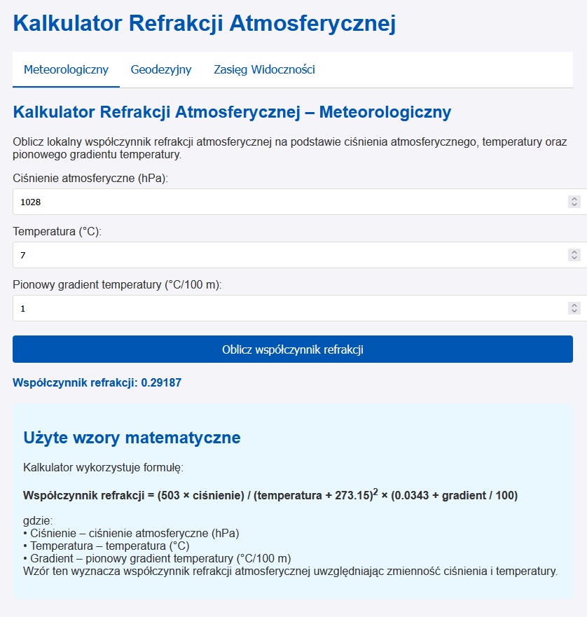
Atmospheric Refraction Calculator
A comprehensive online tool that allows for precise analysis and calculation of parameters related to atmospheric refraction and visibility range.
Go to the Refraction Calculator app
Available calculation modules:
- Meteorological Module: Used to calculate the local refraction coefficient
kbased on atmospheric data: pressure, temperature, and its vertical gradient. - Geodetic Module: Allows for determining the refraction coefficient that must have occurred for an observed object to be visible exactly behind another point. This function is useful for analyzing phenomena in captured photographs.
- Range Calculator: Allows for calculating the theoretical maximum visibility distance, taking into account the height of the observer, the height of the object, and a known value of the refraction coefficient.
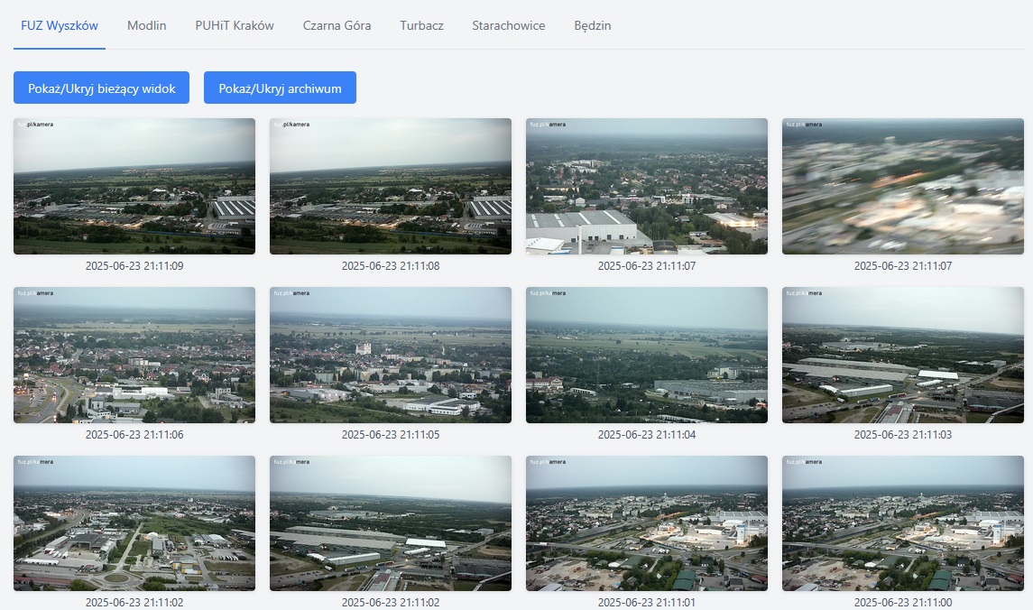
Online Rotating Cameras
A custom system for monitoring and archiving images from online cameras
This is a custom-built system for the automatic monitoring and archiving of images from selected, publicly available rotating webcams. The project’s back-end is based on a Raspberry Pi minicomputer, which runs dedicated scripts to cyclically download images from the cameras.
The application creates a unique visual archive, which allows for the analysis of historical visibility conditions and the search for optimal shots without the need for hours of manual live-stream tracking, thus saving a significant amount of time.
The system currently monitors the following locations and observation targets:
- Tatra Mountains Visibility: Cameras located in Kraków (PUHiT), Będzin, Turbacz, and Czarna Góra.
- Warsaw Panorama Visibility: Cameras in Wyszków (FUZ) and Modlin.
- Świętokrzyskie Mountains Visibility: Camera in Starachowice.
Key capabilities:
- Automatic archiving: The system independently downloads and saves frames from multiple cameras at regular intervals.
- Time-saving: Eliminates the need to manually track live streams in search of good conditions.
- Historical analysis: Allows for Browse archival shots from different days and times to find the best air clarity.
- Centralized view: Provides access to images from several key locations in one convenient place.
External Panorama Generators and Visibility Simulators
Web Applications (browser-based)
Heywhatsthat
Ulrich Deuschle’s Panorama Generator
- Tool’s homepage
- Description of how to create simulations (dalekiehoryzonty.pl, in Polish)
- Object identification using simulation overlays (dalekiehoryzonty.pl, in Polish)
Peakfinder
(Also available as a mobile app)
Desktop Software (for computer installation)
Kashmir 3D
- Program’s homepage
- Configuration and panorama creation guide (dalekiehoryzonty.pl, in Polish)
- Download SRTM1 terrain model data for the Tatra Mountains (dalekiehoryzonty.pl)
- Download file with peak names (dalekiehoryzonty.pl)
Mobile Applications
- Peakfinder: www.peakfinder.org
- Planit Pro: A photography planning app that considers the position of the Sun, Moon, and Milky Way, among other features.
Other Useful Resources
Aeronautical Obstacle Map (PANSA)
An official map maintained by the Polish Air Navigation Services Agency (PANSA), crucial for identifying tall man-made objects.
National Geoportal (Poland)
The official portal with Polish spatial data, offering advanced analytical functions.
- Go to the Geoportal.gov.pl service
- Useful functions and layers:
- Terrain Profile (Digital Terrain Model): Used to verify elevation and the terrain profile along a given line.
- Visibility Analysis along a line (Digital Terrain Model): Allows for analyzing obstacles on the line of sight.
- Zones around wind turbines (Spatial Planning): Helps in identifying wind farms.
Poprawiłem opis jednego szczytu w widoku ze szczytu Příčný vrch , czasem wkradną się jakieś literówki.
Tak to było w sobotę rano. Były świetne warunki do DO. Zacząłem od Granicznego Wierchu (piękne miraże Tatr wyszły), potem…
Czy tak było wczoraj (w sobotę)? Jeśli tak, to fajnie, że ktoś pojechał w teren i wykorzystał warunki. Widziałem już…